It is currently Fri May 10, 2024 4:22 pm


Castles in Ireland

  • Author
  • Message
Offline
User avatar

Tricia

Site Admin

  • Posts: 4181
  • Joined: Mon Jun 30, 2014 7:28 pm

Re: Castles in Ireland Co Cork

PostWed Dec 17, 2014 11:26 pm

Oh right doHH you :D
My ipad controls my spellings not me so apologies from it in advance :) lol
Offline
User avatar

Fairlie

Global Moderator

  • Posts: 1576
  • Joined: Mon Jun 30, 2014 8:02 pm

Re: Castles in Ireland

PostThu Dec 18, 2014 4:16 pm

Caherminnaun Castle, Site of

Site of Caherminaun Castle.jpg
Site of Caherminaun Castle.jpg (133.43 KiB) Viewed 16228 times

Little remains of the castle where in 1591, Murrough O'Brien, the Lord of Caherminnaun died. It was located behind the Coop Livestock Auction house about east of the town of Kilfenora.
Offline
User avatar

Fairlie

Global Moderator

  • Posts: 1576
  • Joined: Mon Jun 30, 2014 8:02 pm

Re: Castles in Ireland Co Clare

PostThu Dec 18, 2014 4:21 pm

Carrigaholt Castle

Carrigaholt_castle_2.jpg
Carrigaholt_castle_2.jpg (117.07 KiB) Viewed 16228 times

Carrigaholt Castle was built in about 1480 by the McMahons, chiefs of the Corcabascin Peninsula. It stands at the end of a fishing pier overlooking the Shannon Estuary and the harbour. This is a tall, well-preserved five storey tower house. It has a fiery and colourful history which would fill volumes.

The castle was occupied by Teige Caech "the short sighted" McMahon in September 1588 when seven ships of the Spanish Armada anchored at Carrigaholt. Although aid was refused by the McMahons (who are descendants of Mathgamain mac Cennétig), the castle was nonetheless unsuccessfully besieged shortly afterwards by Sir Conyers Clifford (Governor of Connaught). The following year the renegade fourth Earl of Thomond (Donagh O'Brien) captured it after a four-day siege and, in breach of the surrender terms, hanged all the defenders.

Ownership then passed to the Earl's brother Donal O'Brien, who was responsible for inserting many of the castle's windows as well as the fireplace on the fifth floor, which bears the date 1603. Donal's grandson was the celebrated third Viscount Clare who resided at Carrigaholt and raised a regiment of horses known as the "Yellow Dragoons" for the House of Stuart King James II of England's armies. After the forfeiture of his extensive 230 km2 (57,000-acre) estate by the Williamites, the castle was acquired by the Burton family.[citation needed]

The castle today is under the care of the Office of Public Works. All that remains is a shell of its former nobility. The Burton Family were the last inhabitants and left it in the late 19th century
Offline
User avatar

Fairlie

Global Moderator

  • Posts: 1576
  • Joined: Mon Jun 30, 2014 8:02 pm

Re: Castles in Ireland Co Clare

PostThu Dec 18, 2014 4:26 pm

Craggaunowen Castle

Craggaunowen Castle Co Clare.jpg
Craggaunowen Castle Co Clare.jpg (92.79 KiB) Viewed 16228 times

Craggaunowen Castle was built around 1550 by John MacSioda MacNamara, a descendent of Sioda MacNamara, who built Knappogue Castle in 1467.

It was left in ruins, uninhabitable and without a roof, in the 17th century. The castle was rendered uninhabitable by the removal of the roof and staircase, and indefensible by removal of the battlements, about 1653, at the time of the Cromwellian confiscations.[citation needed]

The Tower House remained a ruin until it and the estate of Cullane House across the road, were inherited in 1821 by "Honest" Tom Steele, a confederate of Daniel O’Connell, "The Liberator".

Steele had the castle rebuilt as a summer house in the 1820s and he used it, and the turret on the hill opposite, as places of recreation. His initials can be seen on one of the quoin-stones to the right outside.[citation needed] Following his death in 1848 the lands were divided, Cullane going to one branch of his family, Craggaunowen to the another, his niece Maria Studdert. Eventually, having passed through the hands of his descendants, the castle and grounds were acquired by the "Irish Land Commission".[citation needed] Much of the poor quality land was given over to forestry and the castle itself was allowed to fall into disrepair.[citation needed]

By the time of the First Ordnance Survey, in the 1840s, the castle was "in ruins" again. In the mid-19th century, the castle, herd's house and 96 acres were reported in the possession of a Reverend William Ashworth, who held them from a Caswell (a family from County Clare just north of Limerick). In 1906, a mansion house here was owned by Count James Considine (from a family based at Derk, County Limerick).

Craggaunowen Castle was restored by John Hunt in the 1960s. Hunt added an extension to the ground floor, which for a while housed part of his collection of antiquities. The collection now resides in the Hunt Museum in the city of Limerick.

The Living Past Experience[edit]
The open air museum was started by John Hunt. It features reconstructions of ancient Irish architecture, including a dolmen, a crannog, and the currach boat used in Tim Severins recreation of "The Voyage of St. Brendan the Abbot". It also shows reconstructions of a Ringfort, Fulachta Fia (Bronze Age cooking and industrial site) and Standing Stone (Ogham Stone).
Offline
User avatar

Fairlie

Global Moderator

  • Posts: 1576
  • Joined: Mon Jun 30, 2014 8:02 pm

Re: Castles in Ireland Co Clare

PostThu Dec 18, 2014 4:29 pm

Doonagore Castle

doonagorecastle Co Clare.jpg
doonagorecastle Co Clare.jpg (32.68 KiB) Viewed 16228 times

Doonagore Castle is a round 16th-century tower house with a small walled enclosure located about 1 km above the coastal village of Doolin in County Clare, Ireland. Its name may mean "the fort of the rounded hills" or the "fort of the goats"; it sits on a hill overlooking Doolin Point and, along with a nearby higher radio mast, is used as a navigational point by boats approaching Doolin Pier. Doonagore Castle is at present a private holiday home, inaccessible to the public.

While a castle was built on the site by Tadgh MacTurlough MacCon O'Connor from stone drawn from the quarry of Trá Leachain some time during the 14th century, the current structure is likely to date to the 16th century.

In 1580, it was owned by Sir Donald O'Brien but it soon fell to the MacClancys (or Clancys).[1]

In September 1588, a ship of the Spanish Armada was wrecked below the castle. 170 survivors were caught by the High Sheriff of Clare, Boetius Clancy, hanged at Doonagore Castle[1] and buried in a barrow near Doolin called Cnocán an Crochaire.


Doonagore Castle from the SW
Doonagore Castle was repaired in the early 19th century, but by the middle of that century had again deteriorated in the care of the Nagle family.

It was restored in the 1970s by architect Percy Leclerc for a private purchaser, an Irish-American named John C. Gorman[1] whose family still owns it.
Offline
User avatar

Fairlie

Global Moderator

  • Posts: 1576
  • Joined: Mon Jun 30, 2014 8:02 pm

Re: Castles in Ireland Co Clare

PostThu Dec 18, 2014 4:34 pm

Dromoland Castle

dromoland_castle_clare_co_munster_ireland_photo.jpg
dromoland_castle_clare_co_munster_ireland_photo.jpg (88.6 KiB) Viewed 16228 times

Dromoland Castle is a castle, now a 5-star luxury hotel with golf course, located near Newmarket-on-Fergus in County Clare, Ireland. Its restaurant, the Earl of Thomond, was awarded a Michelin star in 1995, under head chef Jean Baptiste Molinari.

Dromoland Castle Hotel is a member of Historic Hotels Worldwide.

The present building was completed in 1835. However, the first building constructed here seems to have been a tower house built in the 15th or early 16th century and is recorded as being erected by Thomas, the son of Shane Mac Anerheny.[3] There were at least three houses on the site, at various times, called Dromoland. While Dromoland later became residence of eight generations of the O'Brien family, early records suggest that the area was also occupied by other local Gaelic families, such as the McInerney family during the 16th century.[4] According to the historian James Frost, Dromoland translates as the "Hill of Litigation"

History
In 1551 Dromoland was listed in the will of Murrough O'Brien. He was first Tanist and in 1543 had been granted the title of first Earl of Thomond by Henry VIII. Murrough bequeathed Leamaneh Castle to his third son Donough MacMurrough O'Brien. He also gave him the castle and lands at Dromoland. In 1582 Donough was hanged in Limerick on charges of rebellion. The government decided that all his property would be forfeited to the Queen. Sir George Cusack, the sheriff, took possession of Dromoland. Some years later, Turlough O'Brien killed Cusack and various O'Briens attempted to re-possess Dromoland. The fourth Earl of Thomond claimed to have sole ownership and tried to exclude Donough's son, Conor MacDonough O'Brien. The outcome of this dispute is unclear.

In 1604 when Conor O'Brien died he left Dromoland to his son, Donough MacConor O'Brien. Donough, whose mother was Slany O'Brien, was then only about eight years old. A legal battle ensued between the fourth Earl and Slany O'Brien. The dispute was settled by arbitration in 1613. The Earl, by now Lord Thomond, became owner of Dromoland on payment of Ј132.13.4. in compensation to Slany O'Brien. When Donough was older, he refused to abide by the settlement. By 1614 a William Starkey was leasing Dromoland from Lord Thomond. By 1628 Lord Thomond was dead and Donough continued the dispute through the Court of Wards and Liveries in Dublin. In 1629 Donough was granted entry "on all the manors, lands and tenements of his late father" on payment of a fine. However, Dromoland was not listed among the many properties named, and it rested with the Earls of Thomond for another fifty years. The fifth Earl did transfer two other properties to Donough as compensation.

Robert Starkey, son of William, was in residence at Dromoland when the rebellion of 1641 began. It seems that he either fled the area or sublet the property. In 1642 Col. Conor O'Brien of Leamaneh, son of Donough and husband of Maire Rua, seized the castle along with a Captain McInerhenny, the leaders of the Irish force, who surprised the guards through help of Starkey's assistant Moran. Conor was killed in battle in 1651. His eldest son Donough, born to Conor and Maire Rua in 1642, was heir to Leamaneh Castle and to the family claim on Dromoland. In addition, Donough inherited large landholdings from his half-brother, William O'Neylan (O'Neillan) (1635–78) of Dysert, to whose father Daniel, Marie Rua had been married from 1634 until his untimely death in 1639.

Robert Starkey resumed the lease and in 1666 Dromoland was sub-leased to Colonel Daniel O'Brien from Carrigaholt Castle. Three years later, it was assigned to Thomas Walcott of Moyhill. Finally, in 1684 the freehold was assigned to Donough O'Brien. At this time Dromoland was a modest house. The original tower house seems to have been added onto during Starkey's time, before Donough moved in from Leamaneh.


Gazebo on Turret Hill.
Through the years visitors to Dromoland have written various descriptions of it. Sir Donough, 1st Baronet, died in 1717. During his time at Dromoland, it was described as "a handsome Grecian Building." Donough's son Lucius also died in 1717 so Edward, son of Lucius, became 2nd Baronet. This first Sir Edward O'Brien decorated the house with pictures and carvings. He also had designs drawn up for a new house. Thomas Roberts and John Aheron both submitted drawings to him for a house and garden at Dromoland. John Aheron appears to have been the architect responsible for the final design. He also designed the Gazebo on Turret Hill, across the road from the main entrance gateway. It was probably built for observing the training of horses. Dromoland was expanded to a ten-bay, 2 1⁄2-storey house. A two-story quadrangle was completed in 1736. Edward died in 1765.

In 1795 an issue of the Gentleman's Magazine gave the following description of Dromoland:

"the noble and beautiful seat of Sir Lucius O'Brien, Bart., in the county of Clare, situated on a hill gently rising from a lake of twenty four acres in the middle of woods. Three beautiful hills rise above it, commanding fine prospects of the great rivers Fergus and Shannon at their junction, being each of them a league wide."

Sir Lucius O'Brien was the eldest son of the first Sir Edward. Lucius was the 3rd Baronet. He died in 1794. His son, the second Sir Edward, was the 4th Baronet. Edward decided to rebuild the castle. In 1821, it was the birthplace of Edward's brother Robert's son, George O'Brien. Work began around 1822 and cost about Ј50,000 to complete. The Pain brothers submitted some classical designs but Edward O'Brien chose their neo-gothic designs, influenced by John Nash. James and George Richard Pain had been pupils of Nash in England. The building was completed in 1835. Samuel Lewis writing in 1837 described Dromoland as:

"a superb edifice in the castellated style, lately erected on the site of the ancient mansion, and surrounded by an extensive and richly wooded demesne, in which great improvements have recently been made".

Edward was married to Charlotte Smith and her inherited wealth was probably essential in covering construction costs of their new mansion. Edward and Charlotte were parents of William Smith O'Brien, the leader of the Young Irelander rebellion of 1848. Sir Edward died in 1837. His eldest son Lucius was 5th Baronet and 13th Baron Inchiquin.


Castellated turret.
Burke's Visitation of Seats (1855) gives the following description of Dromoland:

"It is built entirely of dark blue limestone, and in fine chiseled workmanship; the ornamental grounds and woods extend over more than 1,500 [6.1 km2] of land…from some of the eminences there are views of the Shannon and Fergus, which, at this part of the country, resembles a large inland lake with island, making Dromoland one of the most beautiful and desirable residences in Ireland."

Dromoland has been preserved with little change since that time. The mansion is in "baronial" or "gothic revival" style. It has four linked irregular castellated turrets. A gothic porch to the north front displays the O'Brien arms. The western portion faces out to the lake, and the east towards the hill where Thomond House now stands. The large walled gardens are to the south. In 1902 the 15th Baron Inchiquin, Lucius, took the old 17th century gateway from Leamaneh and erected it at the entrance to the large walled garden. A long curving drive leads from the gateway and classical lodge, passing north of the lake and round to the front door of Dromoland Castle.

In 1962, Donough O'Brien, the sixteenth Baron Inchiquin, sold Dromoland Castle and 350 acres (1.4 km2) because of difficult financial circumstances. He built Thomond House on a hill overlooking Dromoland. He moved into this Georgian style house in 1965 and died in 1968. The house is now occupied by the 18th Baron Inchiquin.

Dromoland Castle was bought by United States citizen, Bernard McDonough. It has since then been converted for use as a top-grade luxurious hotel.

Famous Guests

George W. Bush, Bertie Ahern, and Romano Prodi at their joint press conference at the Castle in 2004.
United States President George W. Bush spent the night of Friday, 26 June 2004, at Dromoland Castle to attend the EU-US Summit held at the facility. President Bush was guarded by approximately 7,000 police, military and private security forces during his 16-hour visit.

Over the years, many famous guests have stayed at Dromoland Castle including Bill Clinton, Juan Carlos I of Spain, Nelson Mandela, Muhammad Ali, Richard Branson, Jack Nicholson, Johnny Cash, Michael Flatley, Bono and John Travolta.
Offline
User avatar

Fairlie

Global Moderator

  • Posts: 1576
  • Joined: Mon Jun 30, 2014 8:02 pm

Re: Castles in Ireland Co Clare

PostThu Dec 18, 2014 4:51 pm

Dromore Castle

Dromore_Castle Co Clare.JPG
Dromore_Castle Co Clare.JPG (14.55 KiB) Viewed 15876 times

Dromore Castle was probably constructed in the early 16th century. In the 17th century, Teige O’Brien of the O'Brien clan repaired and expanded it. The castle and lands of Dromore had been granted to Teige's father, Connor (Third Earl of Thomond), in 1579. Dermot, son of Teige, was an important protagonist in the Confederate Wars and participated in the Siege of Ballyalla Castle (Ennis). The last O'Brien at the castle was Conor, who left in 1689. The castle fell into ruin in the 18th century.

In 1814, Jonas Studdert, third son of Richard Studdert of Clonderalaw, lived in Dromore House. He had married Mary Crowe of Dromore in 1795. In 1837, the house was the home of R. Crowe. Although it was originally a hunting lodge, it became the main seat of the Crowe family in the 1830s.[3] In 1855, during Griffith's valuation, Thomas Crowe was listed as occupier ("in fee") of Dromore and neighbouring Cahermacrea townlands and some others.In 1901, the Census listed Thomas Crowe as proprietor.

Dromore House was sold in 1936 and later demolished. Dromore Wood was bought by the Irish state in the 1940s and subsequently used as a commercial forest. In the 1980s, the National Parks and Wildlife Service (Office of Public Works) took over. In 1985, the area became a statutory nature reserve.

Other historical sites nearby include ruined Cahermacrea Castlethe remains of Kilbakee Church, two ring forts, a limekiln, a children's burial ground and a chapel.[
Offline
User avatar

Fairlie

Global Moderator

  • Posts: 1576
  • Joined: Mon Jun 30, 2014 8:02 pm

Re: Castles in Ireland Co Clare

PostThu Dec 18, 2014 5:13 pm

Gleninagh Castle

gleninagh-castle Co Clare.jpg
gleninagh-castle Co Clare.jpg (33.51 KiB) Viewed 16227 times

Gleninagh or Glaninagh (Irish: Gleann Eidhneach is a civil parish in County Clare, Ireland. It lies in the extreme northwest of the Burren, on the south of the mouth of Galway Bay. It is known for the well-preserved L-plan Gleninagh Castle.

The name "Gleninagh" means the valley of ivy. The parish is in the northwest corner of the barony of Burren. It is 13 miles (21 km) north of Ennistymon. The parish is 2 by 0.75 miles (3.22 by 1.21 km) and covers 4,292 acres (1,737 ha). It contains the bold cape of Black Head, at the south side of the entrance to Galway bay. The land is broken and mountainous.

Antiquities[edit]
As of 1897 the ancient church of Gleninagh was in a good state of preservation.[2] The church was described in 1839 as being mantled in thick ivy. The floor measured 38 by 13.33 feet (11.58 by 4.06 m). The walls were 2.5 feet (0.76 m) thick and about 8 feet (2.4 m) high. The south wall had a pointed doorway of cut stone that was 5.33 feet (1.62 m) high, measured to the vertex of the arch, and 3.1 feet (0.94 m) wide. The south wall had two windows, one quadrangular and the other round-topped, both fairly recent. There was a window in the east gable about 8 feet (2.4 m) high and 3.66 feet (1.12 m) wide. In the outside the window opening was 5.5 inches (140 mm).[4]

Nearby there was a holy well dedicated to the Holy Cross, in Irish Tobar na Croiche Naoimh. The well has a little turry over it, with a symbol of the Redemption of Man on top. It was thought that performing Stations at the well would help with problems with the eyes. Another well called Tobar Cornain is in the townland of Gleninagh North.[4] There is a large heap of stones called Dough Branneen (the heap of little Bran) in the townland of Aughaglinny. There is a stone ringfort called Caher doon Fergus in the townland of Murroogh with caves underneath it, said to be haunted.[2]

The 16th-century Gleninagh Castle, an L-shaped tower house, stands on a hillside looking out over Galway Bay.[5] The tower measures 31.8 feet (9.7 m) by 27.6 feet (8.4 m). In 1839 it was thatched with straw. There are four stories. The single square turret contains a spiral stairway. The entrance doorway on the first floor of the turret is protected by a machicolation high above. There are round bartizans in three of the main tower's corners. A number of window openings in the end wall were later closed so they could be used for fireplaces.

History
In 1544 King Henry VIII of England granted Gleninagh to Richard Harding. The castle was owned by James Lynch of Galway in 1570. The O'Loughlins, who called themselves "Princes of Burren", owned the castle by 1574. The lands of Gleninagh were owned by the see of Kilfenora in 1629. The O'Loughlins later regained possession of the castle. They still lived there until the 1840s.

In 1837 a parish was in the Catholic union or district of Glyn, or Glenarraha.[7] The population in 1841 was 886 in 146 houses. In 1845 the main settlements were the villages of Glaninagh, Murroghkelly and Murroghwohy.[3] A visitor in 1843 said the castle was being used as a barn by Mr. Blood, its proprietor. The upper part of the building was used as a dove-cot and abounded in pigeons
Offline
User avatar

Fairlie

Global Moderator

  • Posts: 1576
  • Joined: Mon Jun 30, 2014 8:02 pm

Re: Castles in Ireland Co Clare

PostThu Dec 18, 2014 5:21 pm

Knappogue Castle

Knappogue Castle Co Clare.JPG
Knappogue Castle Co Clare.JPG (14.62 KiB) Viewed 16227 times

Knappogue Castle (Irish language: Caisleán na Cnapóige) is a tower house, built in 1467 and expanded in the mid-19th century, located in the parish of Quin, County Clare, Ireland. It has been restored and is open to guided tours.


History
The original castle was built in 1467 by Seán Mac Conmara (or MacNamara), son of Sioda MacNamara, and is a good example of a late medieval tower house. The castle's name translates as "castle of the place abounding in little hills".[1]

In 1571, the castle became the seat of the MacNamara (Mac Conmara) sept, the Earls of West Clancullen. Donnchadh Mac Conmara was a leader of the Irish Rebellion of 1641 and Knappogue remained in MacNamara hands throughout the Irish Confederate Wars of the 1640s. After the Cromwellian conquest of Ireland (1649–53) it was confiscated in accord with the Adventurers' Act and its new owner was a roundhead, Arthur Smith.

Arthur Smith occupied the castle from 1659 to 1661. After the monarchy was restored in 1660, Knappogue was returned to its MacNamara owners. Eventually, Francis MacNamara, High Sheriff of Clare in 1789, sold the castle to the Scott family of Cahircon in 1800; the latter carried out major restoration and extension work. In 1837, the castle was owned by William Scott

In 1855, the castle was acquired by Theobold Fitzwalter Butler, 14th Baron Dunboyne. It became the family seat of the Dunboyne family. They continued the restoration work of the Scotts, adding a drawing-room, the long room and a west wing, including the clock tower and the gateway. The remodelling was done by architects James Pain and his brother George Richard Pain.

During the War of Independence (1919–21), Clare County Council held their meetings at Knappogue Castle where they were guarded by the East Clare Flying Column. Michael Brennan, Commander of the East Clare Brigade also used the castle as his headquarters during that time

In 1927, Knappogue demesne was purchased by the Irish Land Commission and the castle became the possession of the Quinn family,[1] local farmers who allowed it to fall into disrepair. The castle and lands were then purchased in 1966 by Mark Edwin Andrews, former Assistant Secretary of the United States Navy, from Houston, Texas. He and his wife Lavonne (a prominent American architect), in collaboration with what was then Shannon Free Airport Development Company (today Shannon Heritage) and Bord Failte Eireann carried out an extensive restoration around 1969.This was intended to accommodate use of the castle as restaurant and private residence.

Their work returned much of the castle to its former 15th century state while encompassing and retaining later additions that chronicle the continuous occupation of the castle.[1] The Andrews later leased part of the castle to the Irish Government as a cultural and tourist facility for a nominal rent.

Today
Shannon Development purchased the castle in 1996. Today, the castle is used as a venue for weddings and medieval banquets and offers guided tours.

Dating from 1817, the 1.248 acre (5,000 m²) garden is now restored to its former state. The walls of the garden have been refurnished with climbing roses, grapevines and many varieties of clematis.

There is also a whiskey named "Knappogue Castle" produced by the Castle Brands company, currently bottling liquor produced by Bushmills
Offline
User avatar

Fairlie

Global Moderator

  • Posts: 1576
  • Joined: Mon Jun 30, 2014 8:02 pm

Re: Castles in Ireland Co Clare

PostThu Dec 18, 2014 5:27 pm

Leamaneh Castle

Leamaneh Castle Co Clare.jpg
Leamaneh Castle Co Clare.jpg (108.68 KiB) Viewed 16227 times

Leamaneh Castle is a ruined castle located in the townland Leamaneh North, Parish of Kilnaboy, between the Villages of Corofin and Kilfenora in the region known as The Burren in County Clare, Ireland. It consists of a 15th-century tower house and a 17th-century mansion.

Name
The castle's name "Leamaneh" is believed to be derived from the Irish "léim an éich" which, when translated into English means "the horse's leap". It is also sometimes spelled "Lemeneagh Castle".

History
Early structure
The castle was originally a basic, 5-storied Irish tower house which was built circa 1480, probably by Toirdelbhach Donn MacTadhg Ó Briain, King of Thomond of the O'Brien family, one of the last of the High Kings of Ireland and a direct descendant of Brian Boru.

In 1543, Turlogh Donn's son, Murrough surrendered his title of King to Henry VIII and was created in 1st Earl of Thomond and Baron Inchiquin. In 1550, Murrough gave Leamaneh to his third son, Donough. Donough was hanged in Limerick in 1582 as a rebel.

Manor house[edit]
In 1639, Donough's grandson, Conor O'Brien married Máire ní Mahon (MacMahon) She became one of the most infamous women in Irish folklore who, due to her flaming red hair, was commonly known asMáire Rúa ("Red Mary"). She was born in 1615 or 1616. Her father was Sir Torlach Rúa MacMahon, Lord of Clonderlaw and her mother was Lady Mary O'Brien, daughter of the third Earl of Thomond. Her first husband, Daniel O'Neylan (also sometimes written O'Neillan or Neylan) of Dysert O'Dea Castle in north Clare died young and upon his death, she gained control of his substantial estate and a £1,000 fortune. This wealth enabled her and Conor to build a more comfortable mansion on to the tower house.

Part of the tower house was demolished and replaced by a 4-storied mansion around 1648. Máire accompanied her husband on raids against English settlers. In 1651, he was mortally wounded by English forces at Inchicronan. Reportedly, immediately after her husband's death, the widow, realizing that the punishment for his rebellion against the English would be the forfeiture of their property, drove to Limerick and offered to marry any Cromwellian officer who would take her hand. (This is refuted in other versions of the story which state that Máire Rúa didn't marry until 1653, two years after Conor's death.)

Her third husband, Cornet John Cooper was a Cromwellian soldier and through this marriage Máire Rúa successfully retained her estates Cooper left the army and amassed some wealth through land and property speculation. However, he later ran into financial difficulty and, as a result, Leamaneh was mortgaged.

In the 1660s, Cromwellian troops were stationed on and off at Leamaneh. Máire Rúa's son, Donagh or Donough (later Sir Donat) found the tower and manor damaged but stayed there until 1685, when he moved the family seat from Leamaneh to the much larger Dromoland Castle in Newmarket-On-Fergus, south of Ennis.

Although Máire Rúa's children from her first marriage to Daniel O'Neylan (or O'Neillan) were raised Catholic, Sir Donagh/Donat was brought up as a Protestant and eventually became the "richest commoner in Ireland."

He served as MP for Clare for over 20 years and died in 1717.

Recent past
Leamaneh had various occupants in subsequent years. However, the house finally fell into ruin at the end of the 18th century.

The barbican-like gates which adorned the entrance to the property were moved to Dromoland Castle in 1908 by Lord Inchiquin.
The most elegant of the fireplaces was relocated to the "Old Ground Hotel" in Ennis.

Today
Today, the ruins include both the tower house and the four walls of the adjoining manor house with their mullioned and transomed windows. Unlike many of the castles in Ireland, Leamaneh is unmaintained. It is located on privately owned land and the area is used for farming. The castle stands on the corner of a three-way intersection in the region known as The Burren.
Offline
User avatar

Fairlie

Global Moderator

  • Posts: 1576
  • Joined: Mon Jun 30, 2014 8:02 pm

Re: Castles in Ireland Co Clare

PostThu Dec 18, 2014 5:34 pm

Newtown Castle

NewtownCastl Co Clare.jpg
NewtownCastl Co Clare.jpg (198.48 KiB) Viewed 16227 times

Newtown Castle is a 16th-century tower house, located close to the village of Ballyvaughan within the Burren area of County Clare, Ireland. Uniquely for a tower house of its type in Ireland, Newtown Castle is round but rises from a square pyramidical base. It is today part of the Burren College of Art.

History
Newtown Castle was built circa 1550 for the O'Brien clan. In the Forfeitures and Distribution books of 1641 it was listed as property of Donogh O'Brien. However, Newtown Castle soon passed into possession of the O'Loughlin (or O'Loghlen) family, the most powerful clan of the area. The Ordnance Survey of 1839 names Charles O'Loghlen as inhabitant of the castle and describes the tower as being in good repair. Charles O'Loghlen was locally known as the "King of the Burren".

In 1848, the landlord, the then Marquess of Buckingham who had been bankrupted sold the local lands. The Buckingham estates in County Clare, around 7,000 acres in the Barony of Burren were purchased for 30,000 pounds by one Richard Samuel Guinness, acting as agent for Colonel Henry White.
At the time of the Griffith's valuation in the 1850s, the building next to the castle, erected c. 1820, was a rectory inhabited by the Reverend Hugh B. Howlett.

At the end of the 19th century Peter O'Loghlen lived in the castle. He was referred to as the "Prince of the Burren".


Newtown Castle is one of only a few cylindrical tower houses in the area. In all of Ireland, only around 30 of the roughly 3,000 tower houses are round. In addition, Newtown Castle features an unusual pyramidical base, which makes it unique in all of Ireland. The tower has four upper floors. The ground floor and first floor feature vaulted ceilings.

Today
Newtown Castle was restored in 1993/1994 for use by the newly established Burren College of Art, which was opened by president Mary Robinson in 1994. It is available as a venue for weddings and conferences. The castle is located on the Burren Way, a long distance trail.[6] The castle is in the townland of Newton, parish of Drumcreehy.[7]

The college opens the tower daily year around
Offline
User avatar

Fairlie

Global Moderator

  • Posts: 1576
  • Joined: Mon Jun 30, 2014 8:02 pm

Re: Castles in Ireland Co Clare

PostThu Dec 18, 2014 5:38 pm

O'Brien's Tower


OBriens_tower Co Clare.jpg
OBriens_tower Co Clare.jpg (35.59 KiB) Viewed 16227 times

O'Brien's Tower marks the highest point of the Cliffs of Moher in County Clare, Ireland, located a short distance from the village Doolin, famous for its traditional Irish music. The tower is also near Liscannor a coastal village famous for its slate flagstones which were used for fencing purposes.

History
The tower was built on the cliffs in 1835 by local landlord Sir Cornellius O'Brien as an observation tower for the hundreds of Victorian tourists that frequented the cliffs at the time. Another version tells of O'Brien building the tower in order to impress women he was courting. On a clear day the view can extend as far as Loop Head at the southern tip of Clare and beyond to the mountains of Kerry. Looking north from O'Brien's Tower on clear days, the Twelve Bens in Connemara (also known as the Twelve Pins) beyond Galway Bay can be seen, and typically the Aran Islands to the west.


O'Briens Tower is just visible in this panoramic view of the Cliffs of Moher.
Folklore holds that Sir Cornellius O'Brien was a man ahead of his time, believing that the development of tourism would benefit the local economy and bring people out of poverty. O'Brien also built a wall of Moher flagstones along the Cliffs and it is said in the locality that he built everything in the area except the cliffs. He died in 1857 and his remains lie in the O'Brien vault in the graveyard adjoining St Brigid’s Well.
Offline
User avatar

Fairlie

Global Moderator

  • Posts: 1576
  • Joined: Mon Jun 30, 2014 8:02 pm

Re: Castles in Ireland Co Clare

PostThu Dec 18, 2014 5:42 pm

O'Dea Castle,


O'Dea Castle, Co Clare.jpg
O'Dea Castle, Co Clare.jpg (46.15 KiB) Viewed 16227 times

O'Dea Castle, also known as Dysert O'Dea Castle, is an Irish fortified tower house, loosely described as a castle[1] at Dysert O'Dea (Irish: Dísert, meaning "hermitage"), the former O'Dea clan stronghold, 5 km from Corofin, County Clare just off the R476 road.[2] It was built between 1470 and 1490 by Diarmaid O'Dea, Lord of Cineal Fearmaic, and stands some 50 feet high on a limestone outcrop base measuring 20 feet by 40 feet.[3] The tower is located right next to Dysert O'Dea Monastery.

History
The Battle of Dysert O'Dea, which drove the Anglo-Normans from the region for over 200 years, took place at this site on 10 May 1318.

The castle was built between 1470 and 1490 by Diarmaid O'Dea, Lord of Cineal Fearmaic. The Earl of Ormond took the castle from the O'Dea clan in 1570 by force. By 1584, however, they had regained it. At that time, Domhnall Maol O'Dea was listed as owner. Domhnall supported the northern Chiefs in the Nine Years' War of 1594-1603 and subsequently Dysert Castle fell to the Protestant Bishop of Kildare, Daniel Neylon, who in 1594 bequeathed it to his son, John. The castle soon returned to the O'Dea clan. Conor Cron O'Dea supported the Confederates and participated in the successful siege of Ballyalla Castle in 1642. After the fall of Limerick in 1651 to the Cromwellian forces, they maintained a small garrison here. When they left, the soldiers demolished the battlements, upper floors and staircase. The Neylon family then returned but during the rein of Charles II, Conor Cron O'Dea regained the castle. Conor's sons, Michael and James, supported the cause of James II and once again lost the castle. The lands passed to the Synge family but the castle eventually and gradually fell into ruin.

In 1970, John O'Day of Wisconsin Rapids, WI, USA, purchased the tower and had it restored. The castle was then leased to the Dysert Development Association, which, with support from the Irish Tourist Board, opened it as "The Dysert O'Dea Castle Archaeology Centre" in 1986. It showed an exhibition of local artefacts from the stone age to 1922.

The tower also won the "Clare Tourism Award" for being one of the most authentically rebuilt castles in Ireland.[citation needed]

Today
Today, the centre is known as the Clare Archaeology Centre, with exhibits of local archaeological artefacts from 1000 BC to 1700 AD, local history over the last three centuries, and a wall walk of parts of the castle. The Dysert O'Dea Archeology Trail includes sites around the tower, including the remains of the Dysert O'Dea Monastery.
Offline
User avatar

Tricia

Site Admin

  • Posts: 4181
  • Joined: Mon Jun 30, 2014 7:28 pm

Re: Castles in Ireland

PostThu Dec 18, 2014 10:33 pm

Some amazing castles in our fair isle Luv reading about them :D thanx fairlie you are doing a great job
My ipad controls my spellings not me so apologies from it in advance :) lol
Offline
User avatar

Fairlie

Global Moderator

  • Posts: 1576
  • Joined: Mon Jun 30, 2014 8:02 pm

Re: Castles in Ireland

PostThu Dec 18, 2014 10:48 pm

There are lots of Castles mentioned in the (wikipedia link), but there is no information on them, mores the pity ,never new ireland had so many castles. :o
Offline
User avatar

Fairlie

Global Moderator

  • Posts: 1576
  • Joined: Mon Jun 30, 2014 8:02 pm

Re: Castles in Ireland Co Cork

PostThu Dec 18, 2014 10:59 pm

Ballinacarriga Castle,

Ballinacarriga Castle, Co. Cork.jpg
Ballinacarriga Castle, Co. Cork.jpg (5.48 KiB) Viewed 16225 times

Ballinacarriga Castle, Co. Cork
Location: From Dunmanway, take R 586 east (toward Ballineen) about six kilometers to R 637. Take R 637 approximately one kilometer south. Take the first side road to the left (it will be within a kilometer and is signposted). Stay to the right. Within about a half kilometer, over Manch Bridge and the Bandon River, not far past the church, the castle will be on the right. There is a carpark about 50 meters past the castle on the opposite side of the road. Climb the steps to the front of the castle.

Dimensions: Set on a high rocky outcropping overlooking Ballinacarriga lough. To the south a stream runs from the lake under a small bridge to join the Bandon River to the North. The stream once provided a supply of water to the castle. This tower measures 14.6 meters and 11.8 meters with a short section of a bawn wall at the northeast corner. The remains of a round flanking tower are just to the east of the castle. The east-facing doorway has been rebuilt but retains a portcullis groove and has corbels for a machicolation above. At the ground level on the south is a guard chamber off the main lobby and a spiral stair rises at the northeast corner. Above the ground floor are six levels of chambers. On the 2nd and 3rd story levels, these subsidiary chambers are accessed from the main chambers of these levels. There are bartizans at the NW and SE corners of the 3rd storey. This level is vaulted. Fireplaces are in the south wall of the 2nd and 4th storeys. The window embrasures at these levels also have carvings.

Features: This is a four storey, six level tower house with an east-facing doorway. On this face of the castle, a sheela-na-gig is positioned high above and to the right of the door between and to the right of the top two right-hand windows (there are three windows above each on this side). Inside at the 2nd storey level, carving in the window embrasure is of a female figure accompanied by five roses, thought to be of Catherine O' Cullane, wife of Randall Hurley, and her five children. Also at this level are intricate and geometric designs. At the fourth storey level, carvings include The Instruments of the Passion of Christ, figures thought to be St John, St. Mary and St. Paul and the initials RM CC and the date 1585. These are thought to be the initials of Randal Muirhily (Hurley) and Catherine O'Cullane.

Comments:The castle is now closed with a locked iron gate, though many have said they were able to trespass inside with relative ease.

History: Ballinacarriga: Beal na Carraige - "the mouth or passage of rock." While the date 1585 appears in the fourth storey carving, it has been suggested that the building is older than this date. This is McCarthy country and it is possible that this was one of McCarthy's holdings before the Hurley's acquired it. The Hurleys had once occupied lands a little over a kilometer to the south, in the townland of Gloun, where some scant remains of buildings are to be seen. The Hurleys forfeited this castle in 1654 whereby it passed to the Crofts. The predominantly religious carvings on the top storey lend credence to the local belief that it was used as a chapel as well as living quarters for the family. Locals also claim that this chapel was still in use until a new chapel was built nearby in 1815, though the tower had been in disuse as a habitation for quite some time.

Other Items of Interest: If one can obtain a key, the carvings are quite nice as is the sheela high on the front (east face) of the tower.
Offline
User avatar

Fairlie

Global Moderator

  • Posts: 1576
  • Joined: Mon Jun 30, 2014 8:02 pm

Re: Castles in Ireland Co Cork

PostThu Dec 18, 2014 11:06 pm

Ballincollig Castle

Ballincollig Castle Co Cork.JPG
Ballincollig Castle Co Cork.JPG (15.01 KiB) Viewed 16225 times

Ballincollig Castle is a Norman castle to the south of the town of Ballincollig, County Cork, Ireland built after the Norman invasion of Ireland. In its prime, the castle was inhabited by the Barretts, who had control of the local area. The castle still stands today, albeit heavily damaged. The original keep still remains, as does most of the curtain wall and two towers set therein.


There appear to be no early descriptions of the castle. Ballincollig Castle was constructed on a limestone summit, with a clear line of sight over the low land of the Maglin Valley. Beneath the castle there is a dark natural cavern which runs into the rock and around it the remains of a moat.

Wall and enclosure
The castle consisted of a large walled enclosure (or bawn), with a tower or keep on one side of it and possibly a large hall through the middle. Most of the enclosing or outer wall remains. It is about 5 ft thick and 15 ft high. The space on top was defended by a parapet with flights of steps leading up at several points. There were two defensive towers on the wall, one at present in ruins in the south-east corner and the second on the south wall.

The enclosure is between 70–100 feet across and is rocky and uneven. There appears to be evidence of a hall in the middle as one portion of the outer wall has the remains of a fireplace and chimney and a window of two lights. It is suggested that the towers on the outer wall and the hall are of 15th century making and were probably built after the sale of the castle to the Barretts.

Keep[edit]

Monogram above tower entrance
On the other hand, the main tower or keep is of the 13th century and was used by Coll. The keep was repaired by the Wyse family in 1857 and on the east wall a shield has been inserted bearing the monogram W with the date 1857 beneath it. The keep is 45 to 50 ft in height. The ground floor is vaulted and originally had no entrance to it except by a trap door from above, so it was probably a prison. The room on the first floor had a path up to it, carried on arches. It is about 7.5 ft by 9 ft. A very narrow staircase leads to other stories, all of which have stone floors on solid arches. To support them the two walls on which they rest are thicker than the others. The second story has seats in the lambs of the loopholes, a drain from a lavatory and a small square cupboard in the wall over it. The upper floor of chief chamber seems to have had windows added on all sides in the middle of the 19th century. However, there are loopholes in other parts of the walls of the keep. The lack of windows and a fireplace and the fact that the small rooms occupied all the internal space between the walls suggests that the building was more of a keep for last defence than a regular living quarters.

History[edit]
Conquest of Ireland[edit]
The Barretts travelled from Normandy with William the Conqueror and helped him to conquer England in 1066.[citation needed] They subsequently received grants of land in Pembrokeshire, Wales. Some of these Barretts travelled with the Normans when they came to conquer Ireland in 1169. When Henry II parcelled out the spoils of conquest in Ireland he gave the Kingdom of Cork, stretching from Lismore, County Waterford to County Kerry, to Milo de Cogan and Robert Fitzstephen. De Cogan received land west and south of the city and the family built a number of castles on their lands including one at Carrigrohane.

The Barretts were underlords of the de Cogans. They rose in influence through service to various kings. The Barretts travelled to conquer Connacht in 1235 under John de Cogan who led the Munster contingent. Because of this they seem to have become tenants of Carrigrohane under John Barrett for King Edward II in wars in Scotland, the king pardoned Crown debts and rents chargeable on his heir, William Barrett.

The Barretts[edit]
During the 15th century the Barretts seem to have settled down to a reasonably peaceful existence. They were now underlords of the McCarthys to whom they paid rent of £11 a year from 1420 and later the Earls of Desmond to whom they paid 12 marks yearly after 1425, when the Desmond were granted de Cogan lands. After the middle of that century they purchased Ballincollig Castle. In the Carew Calendar, 28 November 1611, Sir Dominic Sarsfield wrote to Lord Carew, "Ballincollig is entailed and was purchased in the 8th year of Edward 4 (1468–9) from Robert Coil, a knight. Deed of entail in my own lands". This was to become the principal Barrett stronghold until the early 17th century when Castlemore Barretts seem to have had (Mourne Abbey), Garrycloyne ( both in the north of the Barony), Castleinch, Ballincollig and Cloghan McUllick about 2–3 miles south or south-west of Ballincollig. The exact location of the latter is not certain. Some historians suggest the present townland of Grange but there is some doubt about this. However, the Barretts also controlled Carrigrohane for some time.

In the 1590s a dispute arose. In July 1591 Andrew Barrett and sixty others assaulted Ballincollig Castle and dispossessed Edmund Barrett, "with swords, guns, great sledges or hammers, skenes, stones and staves". Three years later Edmund got a decree of £100 against Sir Fineen O'Driscoll, Sheriff of Cork, for refusing to execute a writ dispossessing Andrew Barrett and others who had seized the castle. In the following year, 1595, Edmund took his cousin to court. A fine of £20 was imposed on Andrew and lesser fines on two others and they were jailed.

Castle lost
However, early in the 17th century, the Barretts lost Ballincollig Castle. The family were driven to borrowing money to pay for court fines and dowries. They had to obtain a mortgage on the castle and lands in 1618 from the Coppingers of Cork who were moneylenders. "William Barrett of Ballincollig in the County of Cork, gent,… in consideration of £240 paid by Edmond Coppinger Fitzrobert of Corke, gent, the said William Barrett granted to the said Edmond Coppinger, his heirs and assigns for ever all that and those the castles, bawnes, towns, villages, hamlets, lands, tenements and hereditaments of and in Ballincolly…”. This mortgage was transferred to Sir Walter Coppinger, Cloghane (near Skibbereen) and in 1630 for the payment of £790 to the Barretts, Coppinger came into full possession of the castle and lands. The castle featured briefly in later history. In 1644 it was taken by Cromwell's forces and around 1689 it was garrisoned for James 2. But after 1690 it was unused and it fell into disrepair.

Today[edit]
Today the castle is in private ownership.
Offline
User avatar

Fairlie

Global Moderator

  • Posts: 1576
  • Joined: Mon Jun 30, 2014 8:02 pm

Re: Castles in Ireland Co Cork

PostThu Dec 18, 2014 11:12 pm

Barryscourt Castle

Barryscourt Castle.jpg
Barryscourt Castle.jpg (45.55 KiB) Viewed 16225 times

Barryscourt Castle (Caisleán Chúirt an Bharraigh in Irish) is a castle located in eastern County Cork in southern Ireland, close to the town of Carrigtwohill.

History
The site on which Barryscourt castle now stands has been occupied for over a thousand years- there is evidence of a wooden watermill having been built next to a stream at the site sometime in the 7th century, long before any fortification existed there. Barryscourt fell into the hands of the Anglo-Norman de Barry family in the 12th century, and masonry from this period found at the site may be the remains of another watermill or possibly an early fortification built by the Barrys.

While the de Barry's lands in various parts of County Cork were divided amongst various branches of the family, Barryscourt remained in the possession of the most powerful branch, the Barrymores (Barra mór or "Great Barry" in Irish). The Barrymore line later went extinct, Barryscourt thus passing to a distant cousin, James FitzRichard of the Barryroes (Barra rua, "Red Barry"), in 1556. The present Tower house at Barryscourt was probably built late in the reign of the Barrymores, either in the 15th or 16th century, with a tentative date of about 1550 based on the architectural style, and became the family seat of the Barrys.

The Barrys supported the Desmond Rebellions of 1569 and 1579, and in 1581 they destroyed or severely damaged the family castles to prevent English forces from capturing them, including Barryscourt, which was threatened by an army led by Sir Walter Raleigh. After the suppression of the second rebellion, the Barrys were pardoned by Queen Elizabeth I and Barryscourt was repaired, with an outer wall or "bawn" surrounding an inner courtyard being added, including 3 corner towers.

Barryscourt ceased to be main residence of the Barry family in 1617, but was evidently still an important fortification for many years afterwards, as it was attacked and captured in 1645, during the Irish Confederate War. The marks caused by the impact of cannonballs during this attack can still be seen on the castle walls.

Barryscourt castle eventually fell into disuse, and a house was built by the Coppinger family (who had taken over the property from the Barrys) next to the castle in the early 18th century; this house has long since disappeared. The Barryscourt Trust was set up in 1987 for the purpose of conserving and developing the potential of the castle as a heritage site. In the 1990s, the relatively intact shell of the tower house was repaired and reroofed by Dúchas, and is now a popular tourist heritage site run by the Office of Public Works. The interior is furnished as it would have been in the 16th century. The castle has daily guided tours available free of charge.


Architecture
Barryscourt castle was built in a style fairly typical in Ireland in the 16th century, consisting of a main tower house building with smaller adjacent buildings arranged around a courtyard, which was protected by an outer "bawn" or curtain wall, with 3 smaller corner towers. A large building once stood next to the main tower inside the bawn, and was probably a dining hall, but only ruins remain. The main tower is situated at the south-west corner of the roughly rectangular curtain wall and the main entrance to the courtyard is right next to it, set into the south curtain wall (there is also a smaller gate in the north curtain wall). The dungeon is a drop-prisoner-in-from-the-top type. Three smaller turrets project from the north-east, south-east and south-west corners of the main tower. These three turrets are 5 storeys high, while the main block of the tower is only 3 storeys high.
Offline
User avatar

Fairlie

Global Moderator

  • Posts: 1576
  • Joined: Mon Jun 30, 2014 8:02 pm

Re: Castles in Ireland Co Cork

PostThu Dec 18, 2014 11:17 pm

Belvelly Castle


Belvelly Castle Co Cork.jpg
Belvelly Castle Co Cork.jpg (18.04 KiB) Viewed 16225 times

Belvelly Castle is a 14th[1] or 15th-century[2] tower house in County Cork. It is situated next to the small village of Belvelly, opposite and defending the only road bridge connecting Fota Island to Great Island (on which the town of Cobh is situated). The castle was originally built by and for the Anglo-Norman Hodnett family,[1] but was taken by the De la Roch (Roche) and De Barra (Barry) families in the 14th-century.[3] The Hodnetts later however leased-back their lands. Some sources suggest that Walter Raleigh occupied the castle in the 16th-century,[4] before being reoccupied by the De Barra family, and used by Roger Boyle, 1st Earl of Orrery to garrison troops during the Irish Confederate Wars in the mid-17th century. By the 19th century the castle had fallen into ruin, but was occupied and somewhat modified by the Irish Army during the Emergency (1939-1945)
Offline
User avatar

Fairlie

Global Moderator

  • Posts: 1576
  • Joined: Mon Jun 30, 2014 8:02 pm

Re: Castles in Ireland Co Cork

PostThu Dec 18, 2014 11:23 pm

Blackrock Castle

Blackrock Castle Co Cork.jpg
Blackrock Castle Co Cork.jpg (26.97 KiB) Viewed 16225 times

Blackrock Castle is a 16th-century castle located about 2 km from the heart of Cork city, Ireland on the banks of the River Lee. Originally built to defend the port and upper flows of Cork Harbour, the castle is now the site of an observatory, visitors centre and restaurant.

Blackrock Castle with Observatory
In the late 16th century, the citizens of Cork appealed to Queen Elizabeth I to construct a fort at Blackrock to "repel pirates and other invaders". Around 1600, a round tower was constructed to safeguard against pirates "carrying away" vessels entering the harbour. The earliest remains of this structure remaining today are a circular tower on the water's edge, 10.5m in diameter, with walls 2.2m thick.

Blackrock Castle was in the ownership of the City of Cork following a charter of James I to the City in 1608. The castle is later referred to in the Council Book of Cork in 1613 and 1614. In 1722 the old four-storey tower was destroyed by fire and new one built by the citizens, costing £296.

Throughout this period, the castle was used by the Corporation for banquets and "convivial gatherings", some associated with the custom of "throwing the dart". This ancient custom was held every three years in August, where a dart (an arrow about four feet long) was thrown from a boat by the Mayor accompanied by officers of the Corporation.

Following a banquet, the castle was destroyed by fire in 1827. The rebuilding began at the direction of Mayor Thomas Dunscombe in 1828 and was completed in March 1829. The architects added three additional storeys to the original tower and rebuilt the out-buildings. The new building cost the City of Cork £1,000.[2] The architects were James and GR Pain, who were responsible for other public buildings and churches in Cork, notably the Courthouse in 1835, the interiors of the Catholic Cathedral of St Mary and St Anne in 1828, and St Patrick's Church in 1836. This neo-gothic complex of buildings around a courtyard is essentially what remains today.

The building was purchased by Cork Corporation in 2001 and had previously been used at different times as offices, as a restaurant and as a private residence.[2]


Floor to ceiling screen with interactive touch pods

Featuring interviews with experts from CIT and ESA
Astronomy center[edit]
In the early-2000s the Castle was redeveloped under a joint venture between Cork City Council, Cork Institute of Technology and a private benefactor.

The "Cosmos at the Castle" project was intended to create a "centre for scientific research, outreach and communication".[3] A feature of the facility is the manner in which children and adults are encouraged to interact with science.[citation needed]

Blackrock Castle now houses Ireland's first interactive astronomy center developed by the award-winning multimedia company Martello Media.[citation needed] The exhibition is open to the public and is themed "The Search for Extreme Life in the Universe". Highlights of the exhibition include:

A tour of the Universe using interactive floor-to-ceiling screens.
A "social software" cinema designed by Martello Media, with digital post production by the award-winning Irish company The Farm
A radio telescope that beams messages composed by school groups towards nearby stars
An optical telescope that continuously searches for very short flashes of light that may be evidence for extraterrestrial intelligence.
The castle already houses a team of astronomical researchers from Cork Institute of Technology who have been working on the exhibits and Ireland's first robotic observatory.[citation needed] At the same time, the team are currently engaged in a number of astronomy projects.
Offline
User avatar

Fairlie

Global Moderator

  • Posts: 1576
  • Joined: Mon Jun 30, 2014 8:02 pm

Re: Castles in Ireland Co Cork

PostThu Dec 18, 2014 11:36 pm

Blackwater Castle

Blackwater Castle Co Cork.jpg
Blackwater Castle Co Cork.jpg (7.15 KiB) Viewed 16225 times

Blackwater Castle (Castle Widenham) is a privately owned estate located in the village of Castletownroche between the towns of Mallow and Fermoy in North Cork, Ireland, and since 2005 is available to rent as a private hire venue for castle weddings and private parties along with castle rentals for vacations. The castle comprises one of the oldest occupied castles in Ireland as parts of the residential section date back to the early 1400s [1] while the castle structure itself dates back to the 12th century. A round tower on the eastern end of the Castle dating from the late 12th century is still standing although no longer accessible. The castle was constructed on the ancient fortress of Dun Cruadha, an inland promontory fort dating back to the late Bronze Age/early Iron Age, while the site itself was first occupied back in the Mesolithic age (circa 9,000 years ago) as evidenced by the flint scatter found at Kilcummer[2] and the caves on the south bank of the River Awbeg making this site one of the earliest known settlements in Ireland.

The Cambro-Norman grandsons of Maurice FitzGerald, Alexander and Raymond FitzHugh, established their fortress on the site of Dun Cruadha in the late 12th century following the Anglo/Cambro - Norman Invasion of Ireland and when Alexander's daughter Synolda married David de la Roche the area subsequently to be known as the Barony of Fermoy became Roche Country. The castle remained in the hands of the Roche family until 1666 when it passed to Colonel John Widenham.[3] Roche Castle then became known as Castle Widenham and stayed within the Widenham family line until the 1960s. A number of different owners followed during which period the castle was substantially renovated and rebranded as Blackwater Valley Castle until it passed into the hands of the Nordstrom Family Trust in 1991.[4] The Trust works at preserving the unique heritage on site by making the castle self-sufficient and the castle, now known as Blackwater Castle, is a thriving centre of hospitality with regular castle weddings, private events, and family gatherings. The courtyard of the castle is also home to an adventure centre, Blackwater Outdoor Activities.

In circumstances where the castle was held by the politically powerful and influential Roches for a period of almost 500 years and subsequently by the wealthy (but politically insignificant) Widenhams for a further 300 years much of the heritage[5] on site remains intact making this a heritage site of international significance. As elements from most eras of Irish History can be reflected in the castle's history it is a popular destination for history and heritage tours[6] as it contains evidence of Mesolithic occupation, late Bronze Age/early Iron Age settlement (inland promontory fort) with evidence of ring barrows and ring forts in the immediate area, a St. Patrick's Holy Well, a Sheela na Gig, Medieval defence walls, a 12th-century tower, a 13th-century watch tower and sentry walk, a 15th-century Norman Keep, the Medieval manuscript The Book of Fermoy (now housed in the Royal Irish Academy[7]), a 17th/18th century courtyard with out-buildings along with a fortified mansion/country house of the post Cromwellian period (subsequently modified and extended)
Offline
User avatar

Fairlie

Global Moderator

  • Posts: 1576
  • Joined: Mon Jun 30, 2014 8:02 pm

Re: Castles in Ireland Co Cork

PostThu Dec 18, 2014 11:39 pm

Blarney Castle

blarney_castle_Co Cork.jpg
blarney_castle_Co Cork.jpg (103.39 KiB) Viewed 16225 times

Blarney Castle (Irish: Caisleán na Blarnan) is a medieval stronghold in Blarney, near Cork, Ireland, and the River Martin. Though earlier fortifications were built on the same spot, the current keep was built by the MacCarthy of Muskerry dynasty, a cadet branch of the Kings of Desmond, and dates from 1446. The noted Blarney Stone is found among the machicolations of the castle.


Blarney Castle, 1954
The castle originally dates from before 1200, when a wooden structure was believed to have been built on the site, although no evidence remains of this. Around 1210 this was replaced by a stone fortification.[4] It was destroyed in 1446, but subsequently rebuilt by Cormac Laidir MacCarthy, Lord of Muscry, who also built castles at Kilcrea and Carrignamuck.

The castle was besieged during the Irish Confederate Wars and was seized in 1646 by Parliamentarian forces under Lord Broghill. However after the Restoration the castle was restored to Donough MacCarty, who was made 1st Earl of Clancarty.

During the Williamite War in Ireland in the 1690s, the then 4th Earl of Clancarty (also named Donough MacCarty) was captured and his lands (including Blarney Castle) were confiscated by the Williamites.

The castle was sold and changed hands a number of times-Sir Richard Pyne, the Lord Chief Justice of Ireland, owned it briefly- before being purchased in the early 1700s by Sir James St. John Jefferyes, then Governor of Cork City.

Members of the Jefferyes family would later build a mansion near the keep. This house was destroyed by fire however, and in 1874 a replacement baronial mansion—known as Blarney House—was built overlooking the nearby lake.


Kissing the Blarney Stone
In the mid 19th century the Jefferyes and Colthurst families were joined by marriage, and the Colthurst family still occupy the demesne.[2] In May 2008, the present estate owner, Sir Charles St John Colthurst, Baronet, succeeded in a court action to eject a man who has lived on his land for 44 years. The man's great-grandfather was the first to occupy the estate cottage.[11]

Tourism[edit]
The castle is now a partial ruin with some accessible rooms and battlements. At the top of the castle lies the Stone of Eloquence, better known as the Blarney Stone. Tourists visiting Blarney Castle may hang upside-down over a sheer drop to kiss the stone, which is said to give the gift of eloquence. There are many legends as to the origin of the stone, but some say that it was the Lia Fáil—a magical stone upon which Irish kings were crowned.

Surrounding the castle are extensive gardens. There are paths touring the grounds with signs pointing out the various attractions such as several natural rock formations which have been given fanciful names, such as Druid's Circle, Witch's Cave and the Wishing Steps. Blarney House, also open to the public, is a Scottish baronial-style mansion that was built on the grounds in 1874
Offline
User avatar

Fairlie

Global Moderator

  • Posts: 1576
  • Joined: Mon Jun 30, 2014 8:02 pm

Re: Castles in Ireland Co Cork

PostFri Dec 19, 2014 9:43 am

Carriganass Castle

Carriganass-Castle Co Cork.jpg
Carriganass-Castle Co Cork.jpg (45.2 KiB) Viewed 16221 times

Carriganass Castle (Caisleán Charraig an Easa in Irish, meaning The Castle on the Rock of the Waterfall) is a 16th-century tower house in County Cork. It is situated about 8 kilometres north-east of Bantry, close to the village of Kealkill, in West Cork.

History
Carriganass Castle was probably built in 1540 by Dermot O'Sullivan, a member of the O'Sullivan Beare sept (or clan), who wielded considerable power in West Cork during the 16th century and early 17th century. The castle passed through the hands of various members of the O'Sullivan clan during a period of internal feuding lasting until 1601, when the O'Sullivans united to support Hugh O'Neill at the Battle of Kinsale. Following the English victory at Kinsale, one of the commanders, Sir George Carew, pursued the O'Sullivan forces back to their base on the Beara Peninsula. A small garrison was left at Carriganass while the bulk of the O'Sullivan force returned to Dunboy Castle; Carew's army easily captured Carriganass before continuing on to lay siege to Dunboy. The O'Sullivans were subsequently dispossessed, and the castle later passed into the ownership of the Barretts, who retained it until the 1930s. During their tenure, a new house was built next to the castle, which deteriorated into its present ruinous state.

Architecture
Carriganass Castle is a typical 16th-century Irish tower house, with a 4-storey tower surrounded by a 14-foot-high outer curtain wall or bawn. The main tower is perched on a rock overhanging the Ouvane river, and has 4 corner turrets. The main entrance to the castle was via a gate in the north wall of the bawn, which had 4 corner towers, the main tower being set into the west wall of the bawn. The castle is now in ruins, with parts of the main tower collapsed.

Carriganass Walks
Carriganass Castle marks the intersection of a number of key West Cork walking routes. The Beara-Breifne Way charts O'Sullivan Bere's march from West Cork to Leitrim on his way to join the Flight of the Earls. From Carriganass you can join loop walks which are part of the Sheep's Head Way network of walking routes. The castle also marks the midpoint of St. Finbarr's Way, a pilgrim path which traces St. Finbarr's journey from Drimoleague to Gougane Barra.
Offline
User avatar

Fairlie

Global Moderator

  • Posts: 1576
  • Joined: Mon Jun 30, 2014 8:02 pm

Re: Castles in Ireland Co Cork

PostFri Dec 19, 2014 9:48 am

Carrigaphooca Castle

Carrigaphooca-Castle Co Cork.jpg
Carrigaphooca-Castle Co Cork.jpg (40.69 KiB) Viewed 16221 times

Carrigaphooca Castle (Irish: Caisleán Carraig a' Phúca), meaning Castle on the Rock of the Fairy; the word Púca translates as kind of ghost or fairy) is a ruined five storey rectangular tower house, situated on a steep-sided rock, located 6 km west of Macroom, County Cork, Ireland. Although named as a castle, the Carrigaphooca was built as a defensive tower in 1436, probably by Donal McCarthy of Drishane. In 1602, the castle was attacked and taken by Donal Cam O'Sullivan Beare.

During the 1970s, the Office of Public Works undertook restoration of the site, and added a flight of steps leading over the rock base, joining with the main entrance. The ground floor chamber is lit by small off-center windows, and is flanked by a straight mural stairs which rises as a spiral to the 4th floor level.

In an area rich with neolithic monuments, a stone circle lies two fields to the east of the tower.
Offline
User avatar

Fairlie

Global Moderator

  • Posts: 1576
  • Joined: Mon Jun 30, 2014 8:02 pm

Re: Castles in Ireland Co Cork

PostFri Dec 19, 2014 9:57 am

Carrigrohane Castle


Carrigrohane Castle is located in the village of Carrigrohane, barony of Barretts in County Cork, Ireland. Now a ruin, it is situated on a rock which overhangs the River Lee. It is said to have been constructed by the MacCarthys. The castle became dilapidated during the troubles of 1641. It was repaired thereafter and became the residence of the rapparee, Captain Cape, and his associated bandits, who waylaid travellers, and plundered the surrounding countryside. It contains dark apartments and vaulted dungeons, enclosed by massive walls. It consists of two piles differentiated by age, altitude, bulk, and architecture, the larger and older of which is oblong, three-storied, and roofless.

Geography
A cave at the base of the rock on which the ruin stands is believed by local residents to communicate with the Ovens caverns, 4 miles (6.4 km) away. A deep pool, called Hell's-Hole, overhung by limestone cliffs, and situated at a river bend above the castle site is imagined to be haunted by a monstrous biped, having a mane like a horse, and a body like an eel.[
Offline
User avatar

Fairlie

Global Moderator

  • Posts: 1576
  • Joined: Mon Jun 30, 2014 8:02 pm

Re: Castles in Ireland Co Cork

PostFri Dec 19, 2014 10:01 am

Castle Donovan

Castle Donovan Co Cork.jpg
Castle Donovan Co Cork.jpg (10.24 KiB) Viewed 16221 times

Castle Donovan (Irish: Caisleán Uí Dhonnabháin) or Castledonovan or O'Donovan's Castle refer to the remains of an Irish tower house or túrtheach, in a valley near Drimoleague, of medium size which was the so-called "seat" of the Clann Cathail sept of the O'Donovans for a period during the 16th century. The original name of the castle, and when the O'Donovans were actually living in it, was Sowagh (or Sooagh, Suagh) before the 17th century. The name of Castle Donovan, after the Manor of the Castle of O'Donovan, is associated with a regrant from James II of England in 1615. Approximately 60 feet in height, it sits on a large rock or outcropping, which forms the ground floor, close to the bank of the River Ilen. It is commonly believed to have been built, or at the very least augmented, by Donal of the Hides, Lord of Clancahill from about 1560 to his death 1584. His son Donal II O'Donovan then repaired or further altered the structure some decades later, but was not living in it by then. It is believed that his father had already relocated the family in the first decade of that century to the more profitable Rahine Manor on the seacoast to protect their maritime interests.

According to tradition the tower was severely damaged by Oliver Cromwell's soldiers in the late 1640s, blown up with powder in retaliation for Donal III O'Donovan joining the Stuart side and for his involvement in the rebellion and massacres of 1641, and has been uninhabited since that time.

In 1834, Philip Dixon Hardy published an account of his 1828 journey to the "vale of Castle Donovan", including a drawing in which several of the outbuildings can still be seen, in the Dublin Penny Journal. He says:[1]

“ ... It is hard to conceive of any thing more wild, more desolate, more lonely, than this savage vale. ... I reached the eminence which commands it from the east, about two in the afternoon of a warm sunny day. Trees there are none in this district, and the heathy covering of the hills was incapable of showing any marks of the advancing season. In the centre of the vale beneath me, was the tall, castellated tower; an extensive marshy meadow lay beyond it, bounded by the steep rocky hills of Mullaugh-Nesha, and its peaked brethren. ”
The tower's surrounding wall or bawn and outbuildings are now gone, but over two thirds of the tower still remain. The 17th century explosion left only a small gouge in the southwest corner, but caused huge cracks in the masonry, leaving the structure unsafe, and over two centuries later the entire western wall, excluding the still intact spiral staircase, and majority of the southern wall collapsed. It underwent conservation[2] by the Office of Public Works between 2001 and 2014[3] and is a listed National Monument.
Offline
User avatar

Fairlie

Global Moderator

  • Posts: 1576
  • Joined: Mon Jun 30, 2014 8:02 pm

Re: Castles in Ireland Co Cork

PostFri Dec 19, 2014 5:10 pm

Castle Harrison

Castle Harrison Co Cork.jpg
Castle Harrison Co Cork.jpg (24.45 KiB) Viewed 16219 times

Castle Harrison, Formerly Castle Dodd, at Charleville, County Cork, Ireland, has long been the seat of a Harrison family of Ireland. Castle Harrison, Ireland (Latitude: 52° 19' 0 N, Longitude: 8° 40' 0 W). Castle Harrison has an area of 2,431acres, according to records of property ownership of 1870.


Castle Harrison, County Cork, Ireland. 19th Century
Barony / Municipal Borough : Orrery and Kilmore

Parish : Ballyhay

County : Cork

Townland : Castleharrison

Present on Ordnance Survey 1" Series

[1st] Yes, sheet 164

[2nd] Yes

[Rev] Yes

Present on Ordnance Survey First Edition 6" Series [1836 to 1846] Yes Barony / Municipal Borough : Orrery and Kilmore Parish : Ballyhay County : Cork Townland : Castleharrison Bibliography Location on Ordnance Survey 1:50,000 Sheet No : 73 Grid Letter : R Grid Reference : 552196 Apparent visibility on current OS and general notes Building indicated area to south labelled 'Castle Harrison'.

The Castle Harrison vault was built by Henry Harrison, of Castle Harrison, who was known as the 'Commissioner'. He was Commissioner of Customs in Ireland about 1710. On the top of this vault is an altar-tomb to some member of the Harrison family, but I cannot read the inscription. I understand that this churchyard is the private property of Colonel Harrison, of Castle Harrison. It is only a short distance from Castle Harrison, and lies about 3½ miles (south-west by west) from Charleville.

According to Lewis it was built on the site of Castle Dod, an old Fitzgerald castle and was inhabited by Standish Harrison in 1837. A map dated 1736 in the National Library includes a drawing of the house then known as Castle Dodd. In the 1940s the Irish Tourist Association Survey noted that it was the residence of Mrs. Harrison, widow of General Harrison. It provides a description of the great hall which contained artefacts that had been unearthed on the estate during the construction of the nearby railway. Castle Harrison was inherited by five sisters in 1951 and the estate was sold to the Land Commission in 1956. The house was subsequently demolished.

Castle Harrison [1] [2]

The Harrison's of Castle Harrison, Charleville, Cork Co., Ireland posted the parchment at the main entrance of the castle for all visitors to see as they entered:

Who originally Descended of Richard, Lord Harrisson, who came into England A.D. 1056, Deriving his Pedigree from Charles, Junior Son of Charles, Duke of Habspruch, in Germany 876, as Sir Thomas Hawley, who was King-at-Arms of George Bretain in the Reign of King Henry VIII, can give Account, Transcripts of which have been carefully Preserved and to me Lineally transmitted by my Ancestors, who were successively Chief Antiquaries of Ireland.

Therefore I, Charles Lynegar, having said Transcripts, or True Copies thereof, have from thence drawn out the following Antiquity, of t he Honourable William Harrison, Esquire, as a Memorial to his Posterity; his Genealogy Extracted from the Root whence Spring his Honourable and Ancient Ancestors. Given under my Hand, Trinity College, Dublin. Second day of August 1727. From your most Obedeint Servant, Charles Lynegar

BALLYHEA, a parish, partly in the barony of ORRERY and KILMORE, but chiefly in that of FERMOY, county of CORK, and province of MUNSTER, 2 miles (S. S. E.) from Charleville; containing 1591 inhabitants. At this place was an ancient castle belonging to the Fitzgerald family, called Castle Dod, which was taken in 1642 by Lord Inchiquin, on which occasion 200 of the Irish were slain. The parish is situated on the river Awbeg, and is intersected by the mail coach road from Cork to Limerick. It comprises 5235 statute acres, as applotted under the tithe act, and valued at £5151 per ann.: the greater portion is under tillage, held in large farms; the land is generally good, and there is some good grazing land, on which store cattle are fattened for the Cork market. Limestone gravel is found in abundance, and burnt for manure. The only seat is Castle Harrison, the residence of Standish Harrison, Esq., erected on the site of Castle Dod. It is a vicarage, in the diocese of Cloyne, forming the corps of the prebend of Ballyhea in the cathedral of Cloyne, and united also to the vicarage of Rathgoggan; the rectory is appropriate to the vicars choral of the cathedral of Christchurch, Dublin; the tithes amount to £400. The church has been long in ruin, and, from its extent and its ornamental details, appears to have been a spacious and handsome edifice. The glebe comprises 2½ acres. In the R. C. divisions the greater portion of the parish is united with the parishes of Ardskeagh, Cooline, Emerick or Imphrick, Aglishdrinagh, and part of the parish of Shandrum: the chapel, a spacious building on the border of Aglishdrinagh, was erected in 1831, on a site given by Mr. Harrison. There are two pay schools, in which are about 50 children.

Cork County Library: Irish Tourist Association survey files, Parish of Ballyhea National Library of Ireland: Harrison Papers. Indenture concerning the acquisition of lands at Ballycoskery, Co. Cork, by S. H. Harrison, estimate by the Land Commission of the value of his estates and agreement by him to purchase lands at Bantry from S. N. Hutchins and others, together with proceedings in Chancery against De Courcy O'Grady by a number of People in respect of debts and lands in Co. Limerick, 1852–1907. MS 8463 National Library of Ireland: Maps of the estate of the Harrisons of Castleharrison, 18th & 19th centuries. 15 B. 22 (36-40) National Library of Ireland: Deeds relating to the lands and affairs of the Harrison family of Castle-harrison, Co. Cork, including the will of Henry Harrison, 1765, three deeds dated 1640 and 1697 and the remainder 18th - 19th century. D 6982–7073 National Library of Ireland: Leases by Henry Harrison, Castleharrison, Ballyhay, Co. Cork, of lands mainly at Ardnageehy, Ballyrydeen, Rathgoggin; lessees include John Barry, Garrett FitzGerald, Thomas Rice; 1765-99. D. 26,388-399 University College Cork, Boole Library Archives: Four account books of S. H. Harrison of Castle Harrison, 19th century. Contemporary printed sources

GRIFFITH'S VALUATION OF IRELAND, 1850–1858. : Barony of Orrery & Kilmore, 13 (Castleharrison) HUSSEY DE BURGH, U. H. The Landowners of Ireland. An alphabetical list of the owners of estates of 500 acres or £500 valuation and upwards in Ireland. Dublin: Hodges, Foster and Figgis, 1878: 206 LEET, Ambrose. A directory to the market towns, villages, gentlemen's seats, and other noted places in Ireland. Dublin: Printed by B. Smith, 1814 : 99 (Castle-harrison) LEWIS, Samuel. A Topographical Dictionary of Ireland. London: S. Lewis & Co., 1837: I, 137 (Castle Harrison) PARLIAMENTARY PAPERS. Return of owners of land of one acre and upwards, in the several counties .... in Ireland. HC 1876, LXXX: 125 SLATER, Isaac. Royal National Directory of Ireland: List of the principal seats. (Manchester: 1894) : xxiv, 131 WILSON, William. The Post-Chaise Companion or Travellers Directory Through Ireland. The author: Dublin, 1786 : 357 (Castle Harrison) Modern printed sources

Jnl. of the Royal Society of Antiquaries Ireland: FITZGERALD UNIACKE, R.G. The Fitzgeralds of Castle Dodd. Ser. 5, Vol. IV (1894), pp. 293–294 BENCE-JONES, Mark. A Guide to Irish Country Houses. Revised ed. London: Constable, 1988. : 70 HAJBA, Anna-Maria. Historical Genealogical Architectural notes on some Houses of Cork. Volume I: North Cork. Whitegate: Ballinakella Press, 2002: 104 MONTGOMERY-MASSINGBERD, Hugh (ed). Burke's Irish Family Records. London: Burke's Peerage, 1976: 554-555 NATIONAL LIBRARY OF IRELAND. Reports on Private Collections: Report on the Harrison Papers (from 1640), formerly the property of Mrs. Barclay, Castle Harrison, Charleville, now in the National Library of Ireland, relating to the Fitzgerald, Casey, and Harrison families and to lands in Co. Cork. No. 299
Offline
User avatar

Fairlie

Global Moderator

  • Posts: 1576
  • Joined: Mon Jun 30, 2014 8:02 pm

Re: Castles in Ireland Co Cork

PostFri Dec 19, 2014 5:19 pm

Castle Pook


Castlepook or Castle Pook is a Norman style castle built in 1380 by the Synan family.
The castle stands at coordinates 52.25356°N 8.56405°W, a few miles north of Doneraile, in the foothills of the Ballyhoura Mountains in County Cork, Ireland.

Castlepook is made of limestone, with a stone vaulted roof which is still intact. There was once a spiral staircase made of stone in the southwest corner.[2] Much of the smooth stone (such as was used for the stairs and window / door frames) has been removed by vandals.

Location
Doneraile, County Cork, Ireland

Description
The ruins of Castle Pook stands five acres on a rocky outcrop near Doneraile at the foot of the Ballyhouras.

The castle is ruined tower. Remains of the defensive wall form a ridge around what would have been the castle courtyard. Parts of a dry moat is visible. There is evidence of the site having been defended since prehistoric times, with traces of a ring for and ancient ramparts having been found on the site.

Facilities
The castle is on private land.

History
Castle Pook was built around 1380 by the Norman, Geoffrey Synan (Geoffrey the Red). It was extended or rebuilt around 1500. The castle was forfeited by the Synans in 1639, and taken over by the St Leger family. The castle is privately owned and there are plans to restore the castle.

Legends
The poet Edmund Spenser lived near the castle and the legends of the castle may have inspired the name Pook in his poem, the Epithalamium. It is believed that the name Puck which Shakespeare used for Robin Goodfellow in A Midsummer Night’s Dream may in turn have been inspired by Spenser’s Pook.
Attachments
Castlepook Co Cork.jpg
Castlepook Co Cork.jpg (47 KiB) Viewed 16219 times
Offline
User avatar

Fairlie

Global Moderator

  • Posts: 1576
  • Joined: Mon Jun 30, 2014 8:02 pm

Re: Castles in Ireland Co Cork

PostFri Dec 19, 2014 5:24 pm

Castle Salem

Castle Salem Co Cork.jpg
Castle Salem Co Cork.jpg (21.05 KiB) Viewed 16219 times

Castle Salem is a fortified house near Rosscarbery, in County Cork, Ireland. The castle was home to the Morris family from around 1660 until the early 1800s, and was bought by the Daly family in 1895 - descendants of whom now run it as a guest house.

Contents [hide]
1 History
2 Civil War period
3 William Morris and the Quakers
4 William Penn
5 The New House (1682)
6 19th Century
7 References
8 External links
History[edit]
According to a Charles Smith,[1] who terms it 'a strong romantic building', Benduff Castle was built by the O'Donovans. However, it was almost certainly built around 1470 by Catherine Fitzgerald,[2] daughter of Thomas 8th Earl of Desmond who married Finghin MacCarthy Reagh The Annals of the Four Masters says that she died in 1506.[3] This Earl, one of the most powerful men in Ireland was Viceroy of Ireland under Edward IV., was executed at Drogheda, in 1466, having fallen a victim, it is said, to the malice of Edward's Queen, Elizabeth Grey, in consequence of his having made a disrespectful speech in reference to her to that King. Earl Thomas's daughter is probably the person who has come down to us as "The Black Lady,"[4] of whom various legends were told in connection with Benduff.

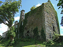
The ancient Castle of Benduff (In Irish Bhinn Dubh 'The Black Peak'), now called Castle Salem (the castle is sometimes referred to as Castlesalem,[5] Castle Sally[6] & Mount Salem[7]), is situated about a mile to the north-west of Rosscarbery, in the bosom of a secluded valley shut in by hills and at one time by a dense plantation of trees. It thus differed from the generality of the feudal strongholds of old which were either perched on a rocky eminence or surmounted the summit of some rising' ground. But the sheltered and isolated position of this castle probably protected it from external danger.

Originally a strong structure, Benduff Castle was built in the usual style of the Norman fortresses which studded Ireland during the Middle Ages, distinguished for their square central keep or tower, with thick massive walls and loop holes for the use of arms as well as the admission of light, to which were generally attached side buildings furnished with bastions, and strong outer walls enclosing the entire foundation — these latter being sometimes provided with covered ways. Benduff Castle has three internal arches; its walls 11 feet thick, with passages and recesses, and the usual stone stairway. It was originally about 70 feet high till old William Morris took the top off, and put on it a slated roof.

Civil War period[edit]
The lands of Knocknamadogue with the Castle of Benduff had been the property of Florence McCarthy, a Roman Catholic rebel whose estates were forfeited by Oliver Cromwell. Ballihagornagh (Barley Hill) had belonged to John Marrigoe, who had a similar history, and most of the rest of the lands had been in the possession of the O'Donovans.

Captain William Morris (abt. 1620–1680) was given over 1500 acres of land, including the castle and he changed the name to Castlesalem. This was in around 1660.[8] The land was formally granted in a grant under the act of settlement in 1678.[9]

To William Morris, gent. Knocknamadogue, to be forever called Montsalem, 252 acres— Kemanabrickey, to be named Libott-Wood, 92 acres—Balanagornaganey, to be called Longnor, 66 acres—Manulagawne or Mullagowne, to be called Mount Stafford, 93 acres 2 roods—Kilbegg, to be called Stoney Furlong, 54 acres—Maulmurreene, to be called Green Furlong, 34 acres 2 roods— Knockrudeene (part) to be called Narrow Furlong, 11 acres—In the Baronies of East and West Carbery. The total quantity being 976 acres 3 roods statute measure at a total rent of £9.3.1 ¾ per annum. Dated 4 September 20 year Charles II. Inrolled 17 September 1666. By patent of 1 November 1678 Mr Morris had an abatement of £2.3.1. 1/3 of his annual rent, so that same was reduced to £7 per annum.

To Captain William Morris. In ye West part of Dunscullis alias Downescully 13 acres (to be forever called by the name of Burton)—Gortroe, 101 acres in ye East part of Dungannon (to be called Wostason)—26 acres (to be called Netley)—in ye East part of Drumuliky 5 acres (to be called ye Mill Pasture), the total quantity being 234 acres 3 roods 18 perches statute measure at a total rent of , £2.3.10 ¾ per annum.

The easterly part of Carhigariff in ye part thereof by an east and west line, 92 acres 2 roods 26 perches (to be called Tullagh)—Bann-u-Iband or Baunare—Ibane, part of Carhugariffe and part of Carren, in ye north part thereof, next adjoining ye lands of Sam Woodriffe, 92 acres 1 rood 14 perches, with a proportionate part of all the unprofitable lands belonging to ye said lands (to be called Blackhurst). At a rent of £2.16.2 per annum. Dated 17 July 21 year Charles II. Inrolled 4 August 1669. By patent dated 1 November 1678 Captain Morris had an abatement of his rent of these lands, so that same was reduced to £2 per annum.

William Morris and the Quakers[edit]
William Morris despite having been a Cromwellian soldier became a Quaker in 1656 and was an active member of the emerging Friends community in Ireland. John Rutty[10] gives an interesting account from the Journal of William Edmondson who describes Captain Morris as a man of talents and influence.

There was also one William Morris, an Elder amongst the Baptists in great repute. Captain of a Company, Justice of the Peace, Commissioner of the Revenues, Chief Treasurer in that Quarter, also Chief Governor of three garrisons, to whom the news of this day's work was soon carried, whereat he was much troubled in mind and told the messenger who was a justice of the peace 'it was a shame for them to suffer us to be so abused' saying 'the time would come that they would be glad to shelter under our wings'. The Rumour soon went amongst the Baptists and to the court at Dublin that Captain Morris was turned Quaker, whereupon he was removed with his company southward; not long after he was sent to Dublin to appear before the General and chief officers, many of whom were Baptists. He was examined about his being turn'd Quaker which he did not deny, but confessed our Faith and Principles and at that time was discharg'd from his command because he was a Quaker. He was a worthy wise man, had a Testimony in our Meetings and died in the Faith of Jesus. I was at Dublin at the time when they took his command from him. He would often say that I was a great help and strength to him in the truth. He was serviceable upon many occasions with the Government in appearing on behalf of suffering Friends, tho' he was also divers times a sufferer in bonds for his testimony. He wrote an excellent short Treatise entitled Tythes No Gospel Ordinance, (printed 1659).

During 1656 William formed a Quaker meeting in Belturbet, County Cavan, with William Parker and his wife and Robert Wardell and his father. Sometime later in 1656 he was discharged from his post and returned to Cork. Like many educated men of his time with financial means he used his influence as a vehicle for change. William had published in 1659 a short treatise entitled Tythes no gospel ordinance. He attempts to prove by reference to Scripture that Tythes are unjust to rich and poor alike and like many Friends this was to get him into trouble with the establishment.

William also wrote a treatise to the English Parliament in 1659. To the Supream Authoritie (under God) of the Commonwealth of England, Scotland, and Ireland, the Commons in Parliament Assembled. The true and faithfull Testimony of William Morris , a late Member of the Army in Ireland. London, Printed for Thomas Simmons, at the Bull and Mouth, near Aldersgate. 4to. 1659. The work seeks to challenge Parliament about the persecution of Quakers in Ireland by Henry Cromwell, Oliver’s fourth son. Henry's principal objective in Ireland was to secure the authority of the Protectorate and to crush all disloyalty. He opposed the Baptists among the soldiers and civilian administrators because of their close association with republicans. By late 1656, Henry had succeeded in forcing leading Baptist officers to resign their commissions or to leave Ireland. He discouraged the spread of Quakerism into Ireland by arresting Quaker missionaries and dismissing army officers who appeared susceptible to their message. On the other hand, he encouraged moderate Presbyterian and Independent clergymen to come over to Ireland. Having suppressed the radicals, Henry worked to reconcile the main Protestant groupings, to gain the support of the gentry and to stabilise the administration. The policy of land seizure and transplanting the native Irish was largely carried out before his appointment as Lord-Deputy, so although he remained suspicious and watchful, Henry's treatment of the Irish Catholics tended to be moderate. Henry supported the succession of his brother Richard to the office of Lord Protector in 1658, but was powerless to prevent the collapse of the Protectorate the following year. He resigned as Lord-Deputy in June 1659 and the Restoration of Charles II just one year away in May 1670.

The work that could have cemented William as a major Quaker theologian and author was written with George Fox and John Perrot entitled, Severall [sic] Warnings to the Baptised People, published in 1659.

Like many of the early Friends William was to suffer for his beliefs and was imprisoned on a number of occasions. Joseph Besse[11] writing in 1753 told how in 1660:

In the County of Cork, William Morris, William Brimsby, Walter Castle, and John Exham, being met with others in Edward Cooke 's House at Bandon-bridge, were committed to Goal by John Laundon, Provost, and put into a nasty Dungeon, where they were kept two Weeks, their Friends not being admitted to bring them Food, but as it was given them through a Grate, and the Provost was offended with the Goaler's Wife, for suffering some Straw to be brought them to lie on.

Following his treatise against the payment of Tythes in 1663/4 Paul and William Morris were sued for tithes by the Archdeacon of Ross but the Archdeacon died suddenly under circumstances which so affected his brother clergy that for some years the Morrises were not again sued for tithes.[12]

A Testimony against John Reeve & Lodowick Muggleton, by the Quakers of Cork, signed by Wm. Morris, Wm. Edmondson, Robert Sandham and 23 others with Muggleton's Sentence of damnation upon them, 'p. 379-401. And the names of many other Friends & things concerning Friends are scattered throughout the vol.

George Fox (1624–1691), the founder of the Quaker faith, despite being unwelcome visited Ireland in 1669. He first visited Bandon then went on to Cork. The mayor was not keen to welcome Fox to Cork. Paul Morris was a brother of William Morris and acted as the guide to George Fox when he rode through the streets of Cork unharmed though there were warrants out against him and even the Mayor recognised him. The Morrises where clearly people of influence.

Fox describes how:

When we came near the town, Friends would have shown me a way through the back side of it; but I told them my way was through the streets. Taking Paul Morrice to guide me through the town, I rode on. As we rode through the market-place, and by the mayor's door, he, seeing me, said, "There goes George Fox"; but he had not power to stop me. When we had passed the sentinels, and were come over the bridge, we went to a Friend's house and alighted. There the Friends told me what a rage was in the town, and how many warrants were granted to take me. While I was sitting there I felt the evil spirit at work in the town, stirring up mischief against me; and I felt the power of the Lord strike at that evil spirit. By-and-by some other friends coming in, told me it was over the town, and amongst the magistrates that I was in the town. I said, "Let the devil do his worst." After we had refreshed ourselves, I called for my horse, and having a Friend to guide me, we went on our way.

William Penn[edit]
Apart from George Fox the other most widely known Quaker is William Penn (1644–1718). As a close friend William Penn often at Castlesalem, particularly in the early months of 1670. Writing in his Irish Journal[13] frequently talks of his time with William Morris. At this time Morris was one of the most prominent Friends in the South of Ireland and clearly respected and admired by William Penn who had him act as his agent in Cork collecting rents etc.[14] It is certain that Penn stayed or visited Castle Salem on February 21, 1670, February 23, 1670, February 24, 1670, February 25, 1670, March 26, 1670, March 29, 1670 - April 3, 1670, April 6, 1670, April 16, 1670.[15] There may have been other time but these are not recorded.

It is certainly a fact that Penn wrote a some of his Great Case of Liberty of Conscience Once More Briefly Debated and Defended at Castle Salem as he refers to it a number of times in his diary.[16]

The New House (1682)[edit]
Rutty describes the death of William in 1680.[17] 'This year died William Morris of Castle Salem in the Co of Cork, who though a man of great parts and wisdom, was convinced of Truth by a weak instrument'. Following the death of his father in 1680 Fortunatus Morris built a new house on to the fortress at Benduff. It is 'L' shaped, the tower being at the angle of the 'L'. It is built of small pieces of bad stone, with a high outside chimney and two gables. Fortunatus’ house was built at its rear against the old building, and from the first landing of its stairs one could step into the Castle by the ancient doorway which was placed about 12 feet from the ground. Later a Georgian hall door was added. The gardens were very extensive and laid out in old Dutch style with ponds, little islands and clipped yew trees.

19th Century[edit]
The Morris family still lived in the castle at the beginning of the 19th century. It was described in 1815[18] as the seat of William Morris. There was an 'old house joined to a castle of still greater antiquity, standing on a rock rising in the centre of a small romantic vale surrounded by steep and lofty hills. Of the trees that were formerly very abundant many still remain, amongst which are a yew and some beech of great size. A very singular circumstance occurs here of a rookery in a grove of laurels'.

The Castle was offered for sale at the encumbered estates court on 3 June 1853[19] and was bought by a Dr. Fitzgibbon for £1,350.[20] In 1870 it was in the hands of Mrs Eliza Fitzgibbon.[21]

Patrick Daly family bought the Castle in 1895 from the Fitzgibbons and 3 generations of the family have now farmed the land. Under the stewardship of Michael and Margaret Daly and their family the Castle tower has been partially restored. It is still a working farm and offers bed and breakfast as well as tours.
Offline
User avatar

Fairlie

Global Moderator

  • Posts: 1576
  • Joined: Mon Jun 30, 2014 8:02 pm

Re: Castles in Ireland Co Cork

PostFri Dec 19, 2014 5:31 pm

Conna Castle

Conna Castle Co Cork.jpg
Conna Castle Co Cork.jpg (279.92 KiB) Viewed 16219 times

Conna (Irish: Conaithe)[1] is a village of some 300 inhabitants in County Cork, Ireland. It is situated on the River Bride, not far from the town of Fermoy. The village contains several pubs, a shop, a post office, a Roman Catholic church and a nearby Church of Ireland chapel. The village is dominated by Conna castle, a five-story tower house situated on a limestone outcrop near the river.

History of the Castle[edit]
In 1554 the Fitzgeralds, Earls of Desmond, began building Conna Castle on a high limestone rock overlooking the River Bride.[2] Construction was completed ten years later. The castle and its estate was seized by the English and passed into the hands of Walter Raleigh, the English settler. The rightful heir to the castle, James FitzThomas (The Sugán Earl) staged a rebellion to capture the castle. He failed, was captured and imprisoned in the Tower of London. The castle then went through a series of different owners before ending up in the hands of the Earl of Cork. It is believed that Oliver Cromwell passed by the castle and fired cannons at it before moving on.[3] In 1653, the castle suffered a fire in which three of the steward's daughters were killed.[4] [5] The castle continued to move from owner to owner until Hilary L’Estrange purchased the castle in 1851. He passed it on to his son, Rev A. G. K. L'Estrange, on whose death in 1915, the castle was willed into the care of the state, the first such property to be so willed.
Offline
User avatar

Fairlie

Global Moderator

  • Posts: 1576
  • Joined: Mon Jun 30, 2014 8:02 pm

Re: Castles in Ireland Co Cork

PostFri Dec 19, 2014 5:36 pm

Dunasead Castle


Dunasead Castle (Dún na Séad in Irish, meaning Fort of the Jewels), is a 17th-century fortified house situated in the town of Baltimore in western County Cork, Ireland.

Contents [hide]
1 History
2 Architecture
3 References
4 See also
History[edit]
The present castle is not the first to have been built on the site. In 1215, an Anglo-Norman settler, FitzStephens, built a tower house with a bawn there, which itself replaced a much older fortification, probably a ringfort. In 1305, the castle was attacked and burned down by one of the most powerful Gaelic septs in the region, the MacCarthys. Another Gaelic sept, the O'Driscolls, much smaller but still powerful in the region, subsequently took possession of Dunasead and rebuilt it.

The O'Driscolls were constantly under pressure from encroachments by Anglo-Norman settlers and rival Gaelic clans on their territory and trade interests, which resulted in the castle being attacked and destroyed numerous times in the following centuries. One especially long-running feud erupted between the O'Driscolls and the merchants of Waterford City in 1368, following an attack on the Waterford fleet by the O'Driscolls. This feud continued on and off for almost two centuries, ending in the sacking of Dunasead, Baltimore and other O'Driscoll castles by another Waterford fleet in 1537.

The castle was rebuilt, but, following the O'Driscolls' support for Hugh O'Neill at the Battle of Kinsale, the castle was surrendered to the English army. Some of the O'Driscolls received pardons, and Dunasead was returned to Florence O'Driscoll, who subsequently leased it out, along with most of his lands, due to financial problems. The present castle was probably built in the 1620s and was surrendered to Oliver Cromwell's forces in 1645. The castle later fell into ruins, but has recently been renovated and is in use as a private residence.

Architecture[edit]
Dunasead is built on a ridge of sandstone in the heart of Baltimore, overlooking the harbour. It consists of a two-storey rectangular building (with an additional attic space) surrounded by a bawn or curtain wall. The main building is set into the south-west wall of the bawn, and measures approximately 6 by 18 metres (20 by 59 ft). This building's defensive features are rather meagre compared to those of the earlier tower houses in the region; on the ground floor, the windows are narrow slits, and there is a bartizan on the south-west corner. Only the bawn could have provided any protection in the event of an attack.
Attachments
Dunasead Castle Co Cork.jpg
Dunasead Castle Co Cork.jpg (119.58 KiB) Viewed 16219 times
Offline
User avatar

Fairlie

Global Moderator

  • Posts: 1576
  • Joined: Mon Jun 30, 2014 8:02 pm

Re: Castles in Ireland Co Cork

PostFri Dec 19, 2014 5:39 pm

Dunboy Castle


Dunboy Castle ruins Co Cork.jpg
Dunboy Castle ruins Co Cork.jpg (11.5 KiB) Viewed 16219 times


Dunboy Castle (meaning Caisleán Dhún Baoi) is a castle on the Beara Peninsula in south-west Ireland near the town of Castletownbere. It was a stronghold of the O'Sullivan Bere, a Gaelic clan leader and 'Chief of Dunboy', and was built to guard and defend the harbour of Berehaven. Its presence enabled O'Sullivan Bere to control the sea fisheries off the Irish coast and collect sizeable taxes from Irish and Continental fishing vessels sheltering in the haven. It was also a centre for the import/export trade to and from the Continent. Today, much of the castle is destroyed but the ruins are open to the public.

Dunboy Castle was the scene of the famous Siege of Dunboy in the summer of 1602 which ultimately led to its destruction and the breaking of the power of the O'Sullivan Bere. At that time Donal Cam O'Sullivan Bere was in rebellion against the English crown and Elizabeth I had sent a 5000-strong army under the command of Sir George Carew to suppress the insurgents. Even with its small garrison of 143 men Dunboy Castle was thought to be impregnable but following a fierce artillery bombardment the walls were smashed and after some desperate hand-to-hand fighting amid the rubble the defenders were finally overcome. The 58 survivors of the two-week siege were executed in the nearby market square.
Offline
User avatar

Fairlie

Global Moderator

  • Posts: 1576
  • Joined: Mon Jun 30, 2014 8:02 pm

Re: Castles in Ireland Co Cork

PostSat Dec 27, 2014 11:25 am

Dunlough Castle

Three Castles, Dunlough, Cork 003s.jpg
Three Castles, Dunlough, Cork 003s.jpg (52.08 KiB) Viewed 16156 times


Dunlough Castle, standing atop the cliffs at the northern tip of the Mizen Peninsula, looks at the Atlantic Ocean from the extreme southwest point of Ireland. Founded in 1207 by Donagh O’Mahony, Dunlough is one of the oldest Norman castles in southern Ireland and an interesting example of Norman architecture and dry stone masonry.

Dunlough Castle is a series of three fortified towers, or keeps, which stand almost invisibly upon the isthmus connecting “Three Castles Head” with the mainland. The only route of access is from the south across private farm land, and the castle appears suddenly as you cross through the hills onto the isthmus. The towers are connected by a wall spanning more than one hundred feet from the western cliffs to the shores of an apparently man-made lake. The wall is mostly fallen today; yet in places it stands approximately 15 feet (4.6 m). At the eastern shore of the lake, a wall from the same period serves as a dam, preventing the lake's water from pouring over the cliffs into Dunmanus Bay several hundred feet below. Passage around the eastern shore of the lake is awkward; while the castle and wall block the western shore. Only a small footpath between the westernmost ruins and the 400-foot (120 m) cliffs allows travelers to visit the towers and the rocky cliffs beyond. As one writer has observed, "To an invading army, the cliff’s edge, the defensive wall, the lake and the sternly inaccessible approach would have made the castle appear impregnable." [1] It is not known if Dunlough was ever attacked.[2]

History[edit]
At the time the first Norman soldiers and settlers arrived in Ireland in 1169, the O'Mahonys were the declining but still powerful princes of Eóganacht Raithlind, occupying approximately the area from Cork City west to Mizen Head.[3] Their regional prominence had been diminished greatly since the MacCarthy dynasty had come south from Tipperary in the early 12th century, and faded even more rapidly as the Normans took hold of southern Ireland.[4] Their primary Irish rivals (and allies) were the McCarthys and the O'Briens. But all these groups were militarily outclassed by the Normans who followed in the wake of King Henry II's initial invasion.

In 1177, King Henry of England granted “the kingdom of Cork” to the Cambro-Norman knights Robert Fitz-Stephen and Milo de Cogan.[5] De Cogan received the lands of west Cork, and began a push toward the Atlantic which drove regional families from the holdings in central Cork. The O’Mahony clan, led by their chieftain Donagh “the Migrator,” settled at the furthest point, the tip of the Mizen peninsula.[6]

Architecture[edit]

As an example of dry stone masonry, Dunough is unusual in that it features three towers with distinct designs, each rather smaller than the typical solitary towers of the region. Designed to fit its environment, the three keeps and the connecting wall would have been a daunting target for invading armies, though it is unknown if any ever attempted to take the castle.

Each keep is three stories high, typical of rectangular towers of its day.[7] No turrets or parapets are present among the remaining structure. The eastern keep was probably the gate tower, though the gateway itself is today in ruins. The western tower is the largest, and was most likely the residence for most of the inhabitants. Typical of "sub-towers" found in larger Norman castles, the central keep provided additional lookout and storage, and served to reinforce the strength of the connecting wall.[8]

Dunlough's interior design is in keeping with other early Irish castles.[9] The presence of a spiral staircase in the eastern tower is offset by the linear staircases of the western tower, while the central tower incorporates both types of stairs. The spiral stairs of the eastern tower are today visible from the outside, due to the crumbling of the outer walls. The simple, rectangular towers of Dunlough foreshadowed the regional castles which were built in later years, many of which still stand. Plain and unornamental, these castles, many of them O'Mahony keeps, rise from the landscape along both shores of the Mizen peninsula.

A common characteristic of the O'Mahony castles, evident at Dunlough's western keep, is the second-storey door. Usually directly above or just to the side of the first-storey entrance, the second-storey door was probably accessed by means of a removable wooden ladder. Inside, the door leads either forward to the second storey (commonly wooden) or upward through the wall to third level. The third storey at Dunlough, as at other O'Mahony castles, is a stone floor which served as the banquet and gathering hall. This was a common feature of most Norman keeps from the early period.[10]

Dunlough's deterioration is attributable in part to the dry stone masonry used in its construction. This method is unusual for castles in this area, which, built in later years, made more use of wet mortar and sand. Yet the use of dry stone masonry was common in earlier Irish buildings.[11]
Offline
User avatar

Fairlie

Global Moderator

  • Posts: 1576
  • Joined: Mon Jun 30, 2014 8:02 pm

Re: Castles in Ireland Co Cork

PostSat Dec 27, 2014 11:32 am

Kanturk Castle

Kanturk Castle Co Cork.jpg
Kanturk Castle Co Cork.jpg (45.11 KiB) Viewed 16156 times


Kanturk (Irish: Ceann Toirc, meaning "Boar's Head" - also the town's emblem) is a town in the north west of County Cork, Ireland. Kanturk is situated at the confluence of the rivers Allow and Dallow (also Dalua), streaming further on as tributaries into the Blackwater. It is about 50 kilometres (31 miles) from Cork, Blarney and Limerick, and lies just north off the main N72 road, 15 km (9 miles) from Mallow and about 40 km (25 miles) from Killarney.

It is a small market town, which after many years with a static population has commenced to grow again.[when?] Apart from its creamery which produced casein from milk, a raw material for early plastics, its former knitwear facility now produces concrete flooring products. The town's schools include Coláiste Treasa and Scoil Mhuire.

History[edit]
A historic site close to the town is Kanturk Castle, a fortified house built in 1601 for MacDonagh McCarthy as a defence against English settlers.[1] It was a limestone rubble Tudor mansion four storeys high, 28 metres in length and 11 metres wide, with four towers of five storeys high and a height of 29 metres. According to legend, the castle was never completed as word of its construction reached the Privy Council in England. They ordered MacDonagh to stop building works, as they feared it would be used as a base to attack English settlers. Macdonogh was allegedly so furious at this news that he smashed all the blue ceramic tiles for the roof and threw them into a nearby stream. The stream then became known as the Bluepool Stream because of the reflection of the tiles in the water. Due to its architectural and historic importance, it is owned by An Taisce (National Trust for Ireland), and is a designated National Monument.

Heritage tourists from the McAuliffe, O'Keeffe, O'Callaghan, Hartnett, Fitzpatrick, Sullivan, Walsh, O'Riordan, and McCarthy families visit Kanturk to investigate familial roots in the area.[citation needed] As families moved during wars and the plantations, some O'Neills, O'Donnells, and other families date their roots in Kanturk from the time of the Siege of Kinsale.
Offline
User avatar

Fairlie

Global Moderator

  • Posts: 1576
  • Joined: Mon Jun 30, 2014 8:02 pm

Re: Castles in Ireland Co Cork

PostSat Dec 27, 2014 11:36 am

Kilbolane Castle

kilbolane-castle- C Cork.jpg
kilbolane-castle- C Cork.jpg (50.8 KiB) Viewed 16156 times


Kilbolane Castle is a historical fortification atop Kilbolane Hill, half a kilometre from the village of Milford, County Cork, Ireland. The castle was built in the 15th or 16th century but employed a 13th-century Norman style[1] with high walls joined by circular guard towers and surrounded by a moat, similar to Liscarroll and Ballincollig.[2]

The castle grounds were church property of the Bishop of Cloyne, from whom it was held, according to the Pipe Roll of Cloyne, in 1291. According to Father Vaughan the Synans had an interest in the place before moving to the Doneraile area.[2] Kilbolane Castle was built shortly after the arrival of Strongbow and the Anglo-Normans,[3] likely as the stronghold of the De Cogans.[2] It was later acquired by the Earls of Desmond[1] and the Fitzgibbon branch of the Fitzgeralds.[3] In 1587 the castle was granted to Hugo Cuffe who was unable to exert real power in the area and in 1590 it reverted indirectly to the Fitzgibbons when it was granted to Sir William Power, husband of Helena Fitzgibbon.[3]

The castle was destroyed by Cromwell's army in 1642[3] leaving only two of its towers intact. On removing the remains of the ancient church, the tomb of the Synan family, bearing the date 1446, was transferred to the new edifice.[3]

The east tower was acquired by captain John Nicholls who built a single story house against the bawn wall and passed the property on to his eldest grandson, John Bowen. John Bowen began to build Kilbolane House at the end of the Castle garden shortly after 1695. A new church was erected in 1832, chiefly at the expense of the Rev. J. Bruce with support of the Ecclesiastical Commissioners.[3]

In 1897 the ruins of Kilbolane Castle, which had been vacant for some years, were purchased by Hannigan. The south tower and west wall remain intact, with maintenance provided by the Board of Works. The view from the southwest provides a glimpse of historical magnificence of the castle, with its high walls and menacing tower
Offline
User avatar

Fairlie

Global Moderator

  • Posts: 1576
  • Joined: Mon Jun 30, 2014 8:02 pm

Re: Castles in Ireland Co Cork

PostSat Dec 27, 2014 11:45 am

Kilcrea Castle

Kilcrea Castle Co Cork.jpg
Kilcrea Castle Co Cork.jpg (12.79 KiB) Viewed 16156 times


Kilcrea Castle is a ruined 15th century towerhouse and bawn located to the west of Kilcrea Friary near Ovens in County Cork, Ireland. The ruins are mostly hidden by a thick copse of trees.

Unlike the Friary, which is owned and maintained by the National Monuments Service of Ireland,[2] the ruins are on privately owned lands, the land immediate to, and including the ruins themselves, currently serving as a cattle farm. The castle is listed as a Protected Structure by Cork County Council.[3]

History[edit]
The castle was completed by 1465 by Cormac Ladir Mór (or More), chief of the McCarthy clan and builder of Blarney Castle and Carrignamuck Tower House, in a marshy area over an old fort possibly dating to the bronze age.[4]

The overall structure was built facing north (towards the River Bride), with the main five-story tower house on the western side and the bawn on the eastern side towards the friary.[5] The remains of a three-story tower anchor the southeast corner of the bawn. Text from the 1840s state that the bawn was enclosed with two square towers,[6] however any physical evidence of a second tower on the bawn is lost to the undergrowth.

In the mid-19th century a cutting of the now disused Cork and Macroom Railway line was built through the moat of the castle on the northern side.
Offline
User avatar

Fairlie

Global Moderator

  • Posts: 1576
  • Joined: Mon Jun 30, 2014 8:02 pm

Re: Castles in Ireland Co Cork

PostSat Dec 27, 2014 11:50 am

Macroom Castle

Macroom Castle Co Cork.gif
Macroom Castle Co Cork.gif (82.88 KiB) Viewed 16156 times


Macroom Castle stands in the town of Macroom, County Cork, Ireland, roughly half way between Cork and Killarney, guarding the historic ford across the River Sullane. It now functions as an hotel.

The main building, based on the original keep, is a three story 6 bay by 3 bay block, which is now covered in ivy. The only other remaining building is the gatehouse and attached walls.

History[edit]
The castle was probably erected in the 12th century by the O'Flynn family, as its Irish name of Caislean-i-Fhlionn suggests. The O'Flynns owned land in this part of what was then the Kingdom of Muskerry, but were overcome by the McCarthys, who were to occupy the Castle until the middle of the 17th century. Tiege MacCarty, father of Lord Muskerry, restored and enlarged the castle and died there in 1565. In 1602 the then owner, Cormac McDermot Carthy, Lord Muskerry was arrested and the castle subjected to siege, during which it caught fire. During the rebellion of 1641, Donough MacCarty, 2nd Viscount Muskerry was visited at the castle by the Papal Nuncio, who stayed for four days.

In 1650 Boetius MacEgan, Bishop of Ross, assembled a Confederation army at the castle, but when the Cromwellian troops of Lord Broghill arrived, the castle garrison again set fire to the building before joining the rebel army in the castle park. During the ensuing battle the Bishop and the High Sheriff of Kerry were taken prisoners, the Sheriff shot and the bishop offered his freedom if he could persuade the garrison of Carrigadrohid Castle to surrender. However, on arrival at Carrigadrohid he chose instead to exhort the garrison to hold on and was hanged from a nearby tree. Later in the war Macroom Castle was said to have been burned yet again by General Ireton.

During the Commonwealth era possession of the castle was given to Admiral Sir William Penn, the father of the founder of Pennsylvania. At the restoration of the Monarchy it was restored to the McCarthys, who further enlarged and renovated it. In 1691 the castle estate was confiscated from Donough MacCarty, 4th Earl of Clancarty for his allegiance to King James II and the castle sold by auction in 1703. It was acquired by the Hollow Sword Blade Co., who resold it to Judge Bernard. It then passed to the Hedges Eyre family and afterwards to Lord Ardilaun. The castle was burned for the last time in 1922, following the evacuation of British Auxiliaries from the town, by anti-treaty forces led by Erskine Childers and Frank O'Connor.

Lady Olivia Ardilaun, a descendant of the McCarthy chiefs, and the widow of Lord Ardilaun, sold the castle demesne in 1924 to a group of local businessmen, to be held in trust for the people of the town.
Offline
User avatar

Fairlie

Global Moderator

  • Posts: 1576
  • Joined: Mon Jun 30, 2014 8:02 pm

Re: Castles in Ireland Co Cork

PostSat Dec 27, 2014 11:54 am

Mitchelstown Castle

Mitchelstown Castle Co Cork.jpg
Mitchelstown Castle Co Cork.jpg (97.94 KiB) Viewed 16156 times


Mitchelstown Castle, the former home of the Irish Earls of Kingston, was located in the north County Cork town of Mitchelstown in Ireland.

15th to 18th century[edit]
White Knights, Dark Earls is to date the most extensive published account of Mitchelstown Castle, which was the biggest neo-Gothic house in Ireland. A castle was first built at Mitchelstown Castle in the 15th century by the White Knights of Mitchelstown, from whom, through marriage, it passed to the King family, Barons and Earls of Kingston. James, 4th Baron Kingston, extensively refurbished and modernised the castle in the 1730s. After his death in 1761, the castle passed to his granddaughter, Caroline Fitzgerald. She married her cousin Robert King, Viscount Kingsborough, who was, from 1797, the 2nd Earl of Kingston. The Kingsboroughs demolished most of the old Mitchelstown Castle in the 1770s and incorporated what remained into a new Palladian mansion, described as a 'house with wings'.

19th century[edit]
In 1823, after his succession, their son, George, 3rd Earl of Kingston, demolished the Palladian house and replaced it with a new castle designed by James and George Richard Pain.[1] It had 60 principal and 20 minor bedrooms, a 100-foot-long (30 m) gallery, three libraries, morning room, dining room (which could seat 100 guests at one sitting) and various other facilities.[2]

Mitchelstown Castle was the biggest neo-Gothic house in Ireland, cost £100,000 to build[3] and became the 'fashion statement' of its time. It inspired other major Irish castles, such as Strancally Castle (County Waterford) and Dromoland Castle for Lord Inchiquin. But the 100,000-acre Mitchelstown estate ran into considerable financial difficulties, which, after the Great Famine of 1845–1851, forced its owners to sell 70,000 acres (280 km2) in the Landed Estates Court. Further difficulties arose as a result of internal family squabbling, legal disputes and the Land War of the 1880s, in which the estate played a prominent part.

20th century[edit]
In June 1922, the castle was forcibly and illegally occupied by the Irish Republican Army. The then owner, William Downes Webber (second husband of Anna, Dowager Countess of Kingston), his relatives and servants were 'evicted' to houses in nearby King Square. Over the next few weeks the castle was held by the Republicans, who appeared to be preparing it for some kind of siege. However, in early August, the contents of the building were stolen by the Republicans. Among the items stolen were paintings by Thomas Gainsborough, William Beechey and Conrod, as well as silver, furniture, wall hangings, and mantlepieces. On 12 August 1922, Mitchelstown Castle was burned on the orders of a local Republican leader whose father and grandfather had been middlemen on the Kingston estate. At the same time, the military barracks at Fermoy, Mallow, Mitchelstown and Kilworth were burned, as well as the military hospital in Fermoy, Mitchelstown workhouse, Mitchelstown RIC barracks and the railway viaduct in Mallow.

Afterwards, William Downes Webber sought compensation from the Irish Free State totalling £149,000 for rebuilding and £18,000 for contents. He intended to rebuild if sufficient compensation was provided. After his death in 1924, Colonel W.A. King-Harman pursued the claim in the Irish courts. Judge Kenny, in the Irish High Court in 1926, stated that the destruction of Mitchelstown Castle had been an act of wanton destruction which had no military purpose. He awarded £27,500 for the building and £18,000 for the contents. Most of this was used to build houses in Dublin as King-Harman decided that it was too small a sum for a rebuilding.

The stones of Mitchelstown Castle were subsequently sold to the Cistercian monks of Mount Melleray Abbey, County Waterford, who used them to build a new abbey.[4] In the 1940s, Mitchelstown Co-operative Agricultural Society built a milk processing factory on the site of the castle, which it had purchased together with some of the demesne lands that surrounded it. The site is now owned by Dairygold Co-op. The coats of arms of Mitchelstown Castle are now held by a local writer and will be erected in Mitchelstown's new public library, which will also have a special section devoted to local history and especially Mitchelstown Castle and its owners.

Famous guests at Mitchelstown Castle included George Bernard Shaw, Mary Wollstonecraft,[5] Arthur Young, Elizabeth Bowen[6] and Prince Hermann von Pückler-Muskau. The King family also produced several important figures, including Viscount Kingsborough, who was the author of 'The Antiquities of Mexico,' and Margaret, Countess Mount Cashell, to whom Percy Bysshe Shelley dedicated his poem 'A Sensitive Plant'.
Offline
User avatar

Fairlie

Global Moderator

  • Posts: 1576
  • Joined: Mon Jun 30, 2014 8:02 pm

Re: Castles in Ireland

PostSun Dec 28, 2014 1:01 pm

Monkstown Castle

Monkstown Castle Co Cork.jpg
Monkstown Castle Co Cork.jpg (35.26 KiB) Viewed 16136 times


In 1539, King Henry VIII awarded the Monkstown lands to Sir John Travers, Master of the Ordnance in Ireland. John Travers lived in his Castle at Monkstown from 1557 to his death in 1562 (he is buried in the Carrickbrennan Graveyard) when the property fell to James Eustace 3rd Viscount Baltinglass through his marriage to Mary Travers. In 1580, the Castle was used as a rebellion stronghold, after which it was awarded to Sir Henry Wallop, Vice-Treasurer of Ireland. The lands were later returned to Mary, the widowed Lady Baltinglass, who later married Gerald Alymer. On her death in 1610 the Castle was transferred to the Chevers family through the marriage of Mary Travers's sister Catherine to John Chevers, and the property passed directly to his second son Henry Chevers, who married Catherine, daughter of Sir Richard Fitzwilliam. Henry and Catherine Chevers lived here with their four children (Walter, Thomas, Patrick, Margaret).[citation needed]

Upon the death of Henry in 1640, the castle and lands were passed to Walter Cheevers. Walter and family received command to vacate Monkstown in 1653 by the Cromwellian Commissioners, and transplanted to Killyan, County Galway. In 1660, Walter Chevers was restored to his estate at Monkstown Castle, until his death in 1678. His death occurred on the 20th day of December 1678, and he was buried at Mountoun (Monkstown), two days later on 22nd.[1] The Shivers family of America trace their lineage to Thomas Chevers brother of Walter Chevers of Monkstown, through the Cromwellian warrant, authorized on 26 November 1653 for Captain John Whittey to transport the Thomas Chevers family to America.

Monkstown was later purchased by the Archbishop of Armagh, Michael Boyle where his son Murrough Boyle, 1st Viscount Blesington enlarged the castle making it one of the finest residences.[citation needed]

Until about 1800, Monkstown was a rural area of open countryside, dotted here and there with large houses owned by the merchants of Dublin. The Monkstown Church (Church of Ireland) had been built – but was smaller than the present church. Two rivers met in the area now called Pakenham Road. The river known as Micky Briens originated in Sallynoggin. A lake beside Monkstown Castle had one small island. The coastline was ragged and rocky, with a harbour stretching over 100 yards inland at the mouth of the aforementioned rivers, adjacent to the area now occupied by the West Pier. Dún Laoghaire (then called Dunleary, and later Kingstown) was then a small group of houses in the area of the Purty Kitchen, and the present area of Dún Laoghaire was an area of rocky outcrops and later, quarries.

Wednesday, November 18, 1807 was South Dublin's night of disasters. In an horrific storm, two sailing ships, the Rochdale and the Prince of Wales were blown on to the rocks, one at Seapoint and the other at Blackrock. About 400 lives in total were lost on that night, many of them washed up on the shore at Monkstown. The disaster was one of the factors which led to the building of Dún Laoghaire Harbour. Most of the victims were buried in Carrickbrennan Churchyard.

The building of Dún Laoghaire harbour gave an impetus to the area, and Montpelier Terrace was the first of many terraces built in the area. The coming of the railway in 1837 had a much greater impact. Firstly, it changed the topology of the coast, and secondly, it led to Monkstown becoming a commuter suburb of the city of Dublin. Most of the houses along Monkstown Road and the avenues north of that road were constructed over the next 30 years. The maps of 1870 show this phase completed, but the rest of Monkstown consists of mansions surrounded by extensive gardens. For the following 50 years there was little change. The post-war developments of Castle Park, Richmond, Windsor, etc. and the more recent developments of Brook Court, Monkstown Valley, and Carrickbrennan Lawn mean that there is little opportunity for further development.

The diaries of the Rev John Thomas Hynes (1799-1868), a Catholic bishop who retired to Monkstown in 1861-68, provide a valuable insight into daily life in Monkstown in that period. Hynes lived at Bloomwood, Monkstown Avenue (later renamed as Carrickbrennan Road), and later moved to Uplands, The Hill, Monkstown. The Hynes Diaries recount such details as the coming of gas lighting, the postal and travel facilities, church affairs, and lots of local gossip. The Hynes diaries are now preserved in Melbourne, but the full text has been made available online
Offline
User avatar

Fairlie

Global Moderator

  • Posts: 1576
  • Joined: Mon Jun 30, 2014 8:02 pm

Re: Castles in Ireland Co Derry

PostSun Dec 28, 2014 1:06 pm

Dungiven Castle

Dungiven-Castle Co Derry.jpg
Dungiven-Castle Co Derry.jpg (69.86 KiB) Viewed 16136 times


Dungiven Castle, in Dungiven, County Londonderry, Northern Ireland, dates back to the seventeenth century although most of the current building dates from the 1830s.[1]

Following a mixed history, which saw it hosting housing the US Army during World War II, and later being used as a dance hall during the 1950s and 1960s,[1] the castle fell into such a state of disrepair that the local council decided to demolish it. A local pressure group fought these plans and in 1989 Glenshane Community Development bought the lease, planning to redevelop the property. Funding was sought and provided by various bodies, including the Heritage Lottery Fund, Limavady Borough Council and the International Fund for Ireland.

In March 2001 Dungiven Castle was re-opened to provide budget accommodation. In 2009 Dungiven Castle underwent a complete redevelopment and redecoration of the entire property. The Castle has now become a 4* Castle Estate.
PreviousNext

Return to Fairlie's Irish Folklore Forum

Who is online

Users browsing this forum: No registered users and 2 guests